1940s Maps of Skagway, Alaska
Explore 5 historic maps of Skagway from the 1940s. These maps offer a rare glimpse into what life looked like during the 1940s — showing old roads, neighborhoods, homes, and landmarks that have changed or disappeared over time.
Whether you're researching your family's past, planning a metal detecting trip, or studying how Skagway's landscape evolved across the 1940s, these high-resolution maps are a powerful tool for exploring the history of this region.
- Focus on a specific era: All maps on this page are from the 1940s, giving you a focused view of this time period.
- See what’s changed: Compare century-old streets, trails, and buildings to today's modern landscape using overlays and satellite layers.
- Research with precision: Use these maps for genealogy, historical research, land use analysis, or educational projects.
- View, download, or print: Maps are fully viewable online in high resolution, and can be downloaded or printed for your own records.
Start exploring Skagway's history through authentic maps from the 1940s. This is your window into the past.
Skagway, AK maps
(5)- 1948 Map of Skagway C-2, 1964 Print
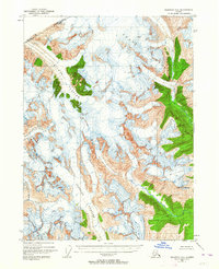 1948 Skagway C-21964 Print · USGSThe international border between Alaska and British Columbia is frozen in time in this mid-century survey of the high Coast Range. Researchers can trace the massive paths of the Chilkat Glacier and Ferebee Glacier as they appeared just after the war.3 unique versions available
 - 1948 Map of Skagway C-1, 1967 Print
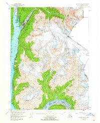
 1948 Skagway C-11967 Print · USGSDuring the late 1940s, the mountainous gateway to the Yukon still centered on the historic Chilkoot Trail and the White Pass and Yukon Route. Researchers can trace the path of early prospectors and rail workers through Finnegans Point, Clifton, and the Inspiration Mine.2 unique versions available
 - 1949 Map of Atlin, 1958 Print
 1949 Atlin1958 Print · USGSThe high borderlands of the Alaskan panhandle are captured here just after the war, detailing the glaciated terrain of the Coast Mountains. Researchers can trace the international boundary as it passes Meade Glacier and prominent summits like Mt Canning and Mt Poletica.
 - 1949 Map of Skagway B-1, 1964 Print
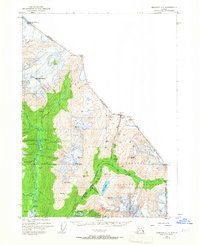
 1949 Skagway B-11964 Print · USGSSkagway at the midpoint of the century remains a vital link between the sea and the interior, dominated by its maritime and rail infrastructure. Researchers can trace the White Pass and Yukon Route railway and find local landmarks like Reid Falls and the Ferry Terminal.3 unique versions available
 - 1949 Map of Skagway D-2, 1965 Print
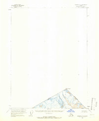 1949 Skagway D-21965 Print · USGSThe northern borderlands at the end of the 1940s reveal a landscape of high summits and international boundaries. Trace the precise path of the Canada-United States line as it crosses the peak of Mt Foster near the British Columbia and Alaska border.
End of results
Showing maps 1-5 of 5
Top cities of Skagway
Frequently asked questions
- What are the different types of historical maps available for Skagway?
- What is the oldest map of Skagway?
- Where can I purchase historical maps of Skagway for my home or office?
- Where can I download high-res historical maps of Skagway?
- Are there historical topographic maps available for Skagway?
- Is there historical aerial imagery available for Skagway?
- Where are historical maps of Skagway sourced from?