1950s Maps of Skagway, Alaska
Explore 6 historic maps of Skagway from the 1950s. These maps offer a rare glimpse into what life looked like during the 1950s — showing old roads, neighborhoods, homes, and landmarks that have changed or disappeared over time.
Whether you're researching your family's past, planning a metal detecting trip, or studying how Skagway's landscape evolved across the 1950s, these high-resolution maps are a powerful tool for exploring the history of this region.
- Focus on a specific era: All maps on this page are from the 1950s, giving you a focused view of this time period.
- See what’s changed: Compare century-old streets, trails, and buildings to today's modern landscape using overlays and satellite layers.
- Research with precision: Use these maps for genealogy, historical research, land use analysis, or educational projects.
- View, download, or print: Maps are fully viewable online in high resolution, and can be downloaded or printed for your own records.
Start exploring Skagway's history through authentic maps from the 1950s. This is your window into the past.
Skagway, AK maps
(6)- 1951 Map of Skagway C-1, 1952 Print
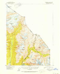 1951 Skagway C-11952 Print · USGSThe borderlands of Southeast Alaska and British Columbia in the early 1950s showcase the famous routes into the interior. Genealogists and historians can trace the White Pass and Yukon railroad and old camp sites like Clifton and Crib.2 unique versions available
 - 1951 Map of Atlin, 1952 Print
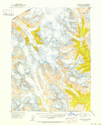
 1951 Atlin1952 Print · USGSThe international boundary between Alaska and British Columbia is charted here at the middle of the century, dominated by the Tongass National Forest. Researchers can trace the rugged border line across high peaks like Mt Poletica and the massive flow of Meade Glacier.
 - 1951 Map of Skagway B-1, 1952 Print
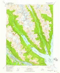
 1951 Skagway B-11952 Print · USGSSkagway and the head of Taiya Inlet are captured here in the early 1950s as a vital transportation hub. Trace the White Pass and Yukon Route and find local landmarks like Reid Falls, Lower Dewey Lake, and the town Powder House.2 unique versions available
 - 1951 Map of Skagway C-2, 1952 Print
 1951 Skagway C-21952 Print · USGSThe international boundary between Alaska and British Columbia is traced across massive ice fields in the early fifties. Researchers can study the extent of Chilkat Glacier and locate high-altitude landmarks like Mt Yeatman and the Ferebee Glacier.2 unique versions available
 - 1952 Map of Skagway, 1953 Print
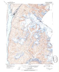
 1952 Skagway1953 Print · USGSThe northern reaches of the Alaska Panhandle come alive in the early fifties, showing the vital rail and road links to the Yukon. Trace the historic White Pass & Yukon Route or locate remote camps like Pleasant Camp and Klukwan.4 unique versions available
 - 1954 Map of Skagway B-2, 1959 Print
 1954 Skagway B-21959 Print · USGSThe Lynn Canal region of Alaska was a landscape of maritime navigation and glacial mountain passes in the mid-fifties. Genealogists and historians can trace the early footprint of the Yindastuki Indian Res and coastal sites like Tanani and Chilkoot.4 unique versions available
End of results
Showing maps 1-6 of 6
Top cities of Skagway
Frequently asked questions
- What are the different types of historical maps available for Skagway?
- What is the oldest map of Skagway?
- Where can I purchase historical maps of Skagway for my home or office?
- Where can I download high-res historical maps of Skagway?
- Are there historical topographic maps available for Skagway?
- Is there historical aerial imagery available for Skagway?
- Where are historical maps of Skagway sourced from?