1950s Maps of Akiak, Alaska
Explore 2 historic maps of Akiak from the 1950s. These maps offer a rare glimpse into what life looked like during the 1950s — showing old roads, neighborhoods, homes, and landmarks that have changed or disappeared over time.
Whether you're researching your family's past, planning a metal detecting trip, or studying how Akiak's landscape evolved across the 1950s, these high-resolution maps are a powerful tool for exploring the history of this region.
- Focus on a specific era: All maps on this page are from the 1950s, giving you a focused view of this time period.
- See what’s changed: Compare century-old streets, trails, and buildings to today's modern landscape using overlays and satellite layers.
- Research with precision: Use these maps for genealogy, historical research, land use analysis, or educational projects.
- View, download, or print: Maps are fully viewable online in high resolution, and can be downloaded or printed for your own records.
Start exploring Akiak's history through authentic maps from the 1950s. This is your window into the past.
Akiak, AK maps
(2)- 1950 Map of Bethel
 1950 Bethel1950 Print · USGSThe Kuskokwim River region in the mid-twentieth century reveals a landscape of remote riverside villages and emerging aviation hubs. Researchers can trace traditional routes like the Winter Trail and locate family-named peaks such as Fisher Dome and Gemuk Mtn.3 unique versions available
 - 1954 Map of Bethel D-6, 1965 Print
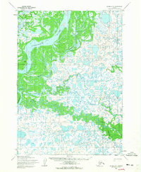 1954 Bethel D-61965 Print · USGSThe riverfront settlement of Akiak serves as the focal point for this mid-fifties survey of the wet Alaskan interior. Researchers can trace the winding paths of the Kisaralik River, Kasigluk River, and the vital Landing Strip at the edge of the tundra.2 unique versions available
End of results
Showing maps 1-2 of 2
Top cities near Akiak
Frequently asked questions
- What are the different types of historical maps available for Akiak?
- What is the oldest map of Akiak?
- Where can I purchase historical maps of Akiak for my home or office?
- Where can I download high-res historical maps of Akiak?
- Are there historical topographic maps available for Akiak?
- Is there historical aerial imagery available for Akiak?
- Where are historical maps of Akiak sourced from?