Old Maps of Angoon, Alaska for Hiking & Exploration
Hike through history with 17 historic maps of Angoon. Explore old trails, ghost towns, and forgotten backroads — perfect for outdoor adventurers and local explorers.
- Rediscover forgotten places: Map out old mining camps, roads, and footpaths that no longer exist on modern maps.
- Layer with modern tools: Combine with LiDAR or satellite views to plan hikes through historical terrain.
- Made for exploration: Popular among hikers, overlanders, and local history lovers.
Use these maps to find adventure and explore the hidden past of Angoon.
Angoon, AK maps
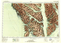
(17)- 1948 Map of Sitka C-2, 1956 Print
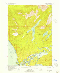 1948 Sitka C-21956 Print · USGSAdmiralty Island in the late 1940s reveals a wilderness of interior lakes and complex coastal inlets. Trace the shoreline of Angoon and find remote outposts like Thayer Lake Lodge and the Danger Pt Lighthouse Reserve.2 unique versions available
 - 1948 Map of Sitka B-2, 1957 Print
 1948 Sitka B-21957 Print · USGSAdmiralty Island's western coastline is documented here just after the war, showing the remote settlements and maritime pathways of the Alaskan panhandle. Genealogists and researchers can locate old sites at Angoon and Killisnoo, or trace early resource extraction at the Coal Mine near Kanalku Bay.
 - 1951 Map of Sitka, 1958 Print
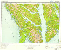 1951 Sitka1958 Print · USGSSoutheast Alaska in the early fifties reveals a landscape defined by water and remote coastal outposts. Genealogists and historians can trace established settlements like Sitka and Angoon alongside industrial markers like a Logging Camp and the Old Sitka ruins.6 unique versions available
 - 1951 Map of Sitka B-2, 1972 Print
 1951 Sitka B-21972 Print · USGSThe western coast of Admiralty Island comes alive in the early fifties, documenting a maritime network of Tlingit settlements and early resource extraction. Trace the shoreline from Angoon to Neltushkin, and locate the Coal Mine at the head of Kanalku Bay.2 unique versions available
 - 1951 Map of Sitka C-2, 1976 Print
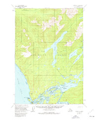 1951 Sitka C-21976 Print · USGSAdmiralty Island in the early 1950s reveals a maritime-focused landscape centered on the village of Angoon and the surrounding wilderness. Genealogists and historians can locate a Cem, the Lighthouse Reserve, and inland outposts like Thayer Lake Lodge.2 unique versions available
 - 1952 Map of Sitka, 1953 Print
 1952 Sitka1953 Print · USGSSoutheast Alaska in the early fifties is mapped here across the islands and straits of the Alexander Archipelago. Researchers can locate coastal outposts like Angoon and Tenakee, or trace the rugged shores of Sitka Sound to the slopes of Mt Edgecumbe.4 unique versions available
 - 1964 Map of Sitka
 1964 Sitka1964 Print · USGSSoutheast Alaska's rugged archipelago is captured in the mid-twentieth century as maritime commerce and coastal outposts shaped the region. Genealogists and historians can trace established settlements like Sitka and Angoon or vanished points such as Gypsum and Manleyville.
 - 2000 Map of Sitka B-2, 2003 Print
 2000 Sitka B-22003 Print · USGSAdmiralty Island at the turn of the millennium shows the enduring community of Angoon and its surrounding wilderness. Researchers can trace the maritime history of Killisnoo Harbor, find a Coal Mine, and locate abandoned sites like Neltushkin (Aband).
 - 2017 Map of Sitka C-2 SW, 2017 Print
 2017 Sitka C-2 SW2017 Print · USGSCovers Angoon, including Unorganized Borough, United States, and other nearby areas
 - 2017 Map of Sitka B-2 NE, 2017 Print
 2017 Sitka B-2 NE2017 Print · USGSCovers Angoon, including Unorganized Borough, United States, and other nearby areas
 - 2017 Map of Sitka B-2 NW, 2017 Print
 2017 Sitka B-2 NW2017 Print · USGSCovers Angoon, including Killisnoo, Unorganized Borough, and other nearby areas
 - 2021 Map of Sitka B-2 NW, 2021 Print
 2021 Sitka B-2 NW2021 Print · USGSCovers Angoon, including Killisnoo, Unorganized Borough, and other nearby areas
 - 2021 Map of Sitka B-2 NE, 2021 Print
 2021 Sitka B-2 NE2021 Print · USGSCovers Angoon, including Unorganized Borough, United States, and other nearby areas
 - 2021 Map of Sitka C-2 SW, 2021 Print
 2021 Sitka C-2 SW2021 Print · USGSCovers Angoon, including Unorganized Borough, United States, and other nearby areas
 - 2024 Map of Sitka B-2 NW, 2024 Print
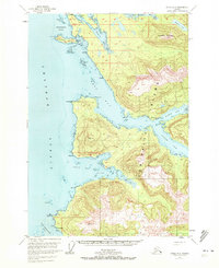
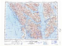
 2024 Sitka B-2 NW2024 Print · USGSThe community of Angoon is captured here in the twenty-first century, situated at the confluence of Kootznahoo Roads and Favorite Bay. Researchers can trace the layout of the town near the Angoon Courthouse or explore the coastal details of Killisnoo Island and Saginaw Point.
 - 2024 Map of Sitka B-2 NE, 2024 Print
 2024 Sitka B-2 NE2024 Print · USGSAdmiralty Island in the early twenty-first century remains a landscape of protected wilderness and coastal heritage. Researchers can trace the layout of Angoon and the remote reaches of Kanalku Lake and Kanalku Bay.
 - 2024 Map of Sitka C-2 SW, 2024 Print
 2024 Sitka C-2 SW2024 Print · USGSThe community of Angoon and the surrounding Admiralty Island shoreline are documented here in 2024. Researchers can trace coastal landmarks like Hell's Acre, Rose Rock, and the intricate channels of Kootznahoo Inlet within the wilderness boundaries.
End of results
Showing maps 1-17 of 17
Top neighborhoods of Angoon
Frequently asked questions
- What are the different types of historical maps available for Angoon?
- What is the oldest map of Angoon?
- Where can I purchase historical maps of Angoon for my home or office?
- Where can I download high-res historical maps of Angoon?
- Are there historical topographic maps available for Angoon?
- Is there historical aerial imagery available for Angoon?
- Where are historical maps of Angoon sourced from?