
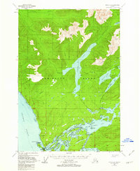
1948 Map of Sitka C-2
USGS Topo · Published 1956About this map
Admiralty Island's intricate coastlines and interior waterways dominate this mid-century survey, centered on the complex marine geography of Kootznahoo Inlet. Near the southwestern corner, the settlement of Angoon stands as a primary point of human activity, adjacent to a designated Cem and the Danger Pt Lighthouse Reserve. The map reveals a landscape defined by water-based transit, where the massive Thayer Lake stretches through the center of the island, connected to the coast by the Fresh Water Thayer Trail.
Find a feature on this map
62 named features on this map. Tap any name to fly to it.
Don’t see what you’re looking for? This feature index may not catch every label — zoom into the map to look around manually.
Map Details
Editions of this 1948 Sitka C-2 Map
2 editions found
Other maps of this area

1948 · Sitka B-3
USGS Topo · 1:63,360

1948 · Sitka D-1
USGS Topo · 1:63,360

1948 · Sitka B-1
USGS Topo · 1:63,360

1948 · Sitka C-3
USGS Topo · 1:63,360

1948 · Sitka D-3
USGS Topo · 1:63,360

1948 · Sitka D-2
USGS Topo · 1:63,360

1948 · Sitka C-1
USGS Topo · 1:63,360

1948 · Sitka B-2
USGS Topo · 1:63,360

1951 · Sitka
USGS Topo · 1:250,000

1951 · Sitka B-3
USGS Topo · 1:63,360