
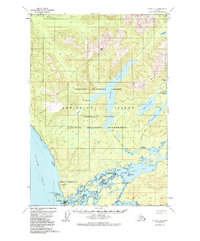
1951 Map of Sitka C-2
USGS Topo · Published 1976About this map
Angoon sits at the southwestern edge of this 1951 coastal survey, serving as a primary settlement on Admiralty Island. The map documents a complex maritime landscape where the waters of Chatham Strait meet the intricate channels of Kootznahoo Inlet. Inland, the terrain is defined by a network of freshwater bodies including Thayer Lake, Distin Lake, and Davidson Lake, connected by the Distin Lake Trail and Portage Trail.
Find a feature on this map
54 named features on this map. Tap any name to fly to it.
Don’t see what you’re looking for? This feature index may not catch every label — zoom into the map to look around manually.
Map Details
Editions of this 1951 Sitka C-2 Map
2 editions found
Other maps of this area

1948 · Sitka B-3
USGS Topo · 1:63,360

1948 · Sitka D-1
USGS Topo · 1:63,360

1948 · Sitka B-1
USGS Topo · 1:63,360

1948 · Sitka C-2
USGS Topo · 1:63,360

1948 · Sitka C-3
USGS Topo · 1:63,360

1948 · Sitka D-3
USGS Topo · 1:63,360

1948 · Sitka D-2
USGS Topo · 1:63,360

1948 · Sitka C-1
USGS Topo · 1:63,360

1948 · Sitka B-2
USGS Topo · 1:63,360

1951 · Sitka
USGS Topo · 1:250,000