Old Maps of Arctic Village, Alaska for Metal Detecting
Plan your next treasure hunt with 4 historic maps of Arctic Village. Find old homesites, ghost towns, trails, and gathering spots that may be lost to time — perfect for identifying promising metal detecting locations.
- Locate forgotten sites: Uncover places like long-lost settlements, abandoned rail lines, or gathering spots.
- Plan better hunts: Use map overlays combined with LiDAR or satellite views to narrow in on historically rich areas.
- Made for detectorists: Thousands of hobbyists use these maps to discover relics, coins, and hidden history.
Use these historic maps to boost your research and find new opportunities beneath the surface of Arctic Village.
Arctic Village, AK maps
(4)- 1951 Map of Arctic, 1952 Print
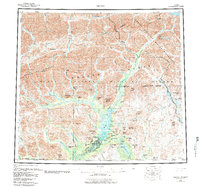
 1951 Arctic1952 Print · USGSThe northern Alaskan interior at the start of the 1950s is documented here through its rivers and isolated mountain outposts. Trace the geography of the Brooks Range and find the remote Arctic Village alongside landmarks like Old John Lake.
 - 1956 Map of Arctic
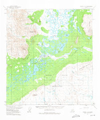
 1956 Arctic1956 Print · USGSThe North Slope wilderness of the 1950s is captured here, showing a landscape of high peaks and river systems before significant development. Genealogists and historians can locate Arctic Village and the John Franks Cabins among features like Old John Lake and the Junjik River.8 unique versions available
 - 1972 Map of Arctic A-3, 1975 Print
 1972 Arctic A-31975 Print · USGSArctic Village and the Venetie Indian Reservation are captured here in the early seventies, showing a landscape defined by the Chandalar River. Local history researchers can trace the Winter Trail, identify the local Cems, and locate the Landing Strip and Gravel Pit.2 unique versions available
 - 2018 Map of Arctic A-3 NW, 2018 Print
 2018 Arctic A-3 NW2018 Print · USGSThe Yukon-Koyukuk region in 2018 shows a remote landscape where the East Fork Chandalar River meets localized roads. Researchers can trace the layout of Main St and Airport St near peaks like Coal Mtn.
End of results
Showing maps 1-4 of 4
Frequently asked questions
- What are the different types of historical maps available for Arctic Village?
- What is the oldest map of Arctic Village?
- Where can I purchase historical maps of Arctic Village for my home or office?
- Where can I download high-res historical maps of Arctic Village?
- Are there historical topographic maps available for Arctic Village?
- Is there historical aerial imagery available for Arctic Village?
- Where are historical maps of Arctic Village sourced from?