1900s (20th Century) Maps of Batzulnetas, Alaska
Explore 5 historic maps of Batzulnetas from the 1900s (20th Century). These maps offer a rare glimpse into what life looked like during the 1900s — showing old roads, neighborhoods, homes, and landmarks that have changed or disappeared over time.
Whether you're researching your family's past, planning a metal detecting trip, or studying how Batzulnetas's landscape evolved across the 1900s, these high-resolution maps are a powerful tool for exploring the history of this region.
- Focus on a specific era: All maps on this page are from the 1900s, giving you a focused view of this time period.
- See what’s changed: Compare century-old streets, trails, and buildings to today's modern landscape using overlays and satellite layers.
- Research with precision: Use these maps for genealogy, historical research, land use analysis, or educational projects.
- View, download, or print: Maps are fully viewable online in high resolution, and can be downloaded or printed for your own records.
Start exploring Batzulnetas's history through authentic maps from the 1900s. This is your window into the past.
Batzulnetas, AK maps
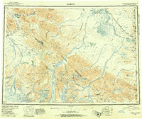
(5)- 1948 Map of Nabesna C-6, 1965 Print
 1948 Nabesna C-61965 Print · USGSThe Slana region in the late 1940s is shown here at the critical junction of the Glenn Highway and Nabesna Road. Genealogists and historians can locate early roadside landmarks like Duffys Tavern, the settlement of Batzulnetas, and several remote Cabins.4 unique versions available
 - 1950 Map of Nabesna, 1954 Print
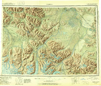
 1950 Nabesna1954 Print · USGSInterior Alaska in the early fifties shows a rugged transition from mountain glaciers to river-basin settlements before statehood. Researchers can trace the remote mining outposts of Nabesna and Chisana or locate old airstrips like Reeve Field and Northway Landing Field.4 unique versions available
 - 1951 Map of Nabesna
 1951 Nabesna1951 Print · USGSThe Alaska interior comes into focus during the early fifties, showing the vast Tetlin Indian Reservation and the rise of bush pilot culture. You can trace the routes of the Alaska Highway and find remote camps like Indian Pass Inn or Chisana.3 unique versions available
 - 1952 Map of Nabesna C-6
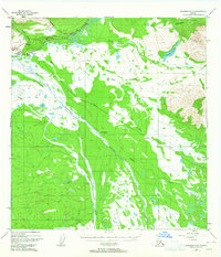
 1952 Nabesna C-61952 Print · USGSThe Alaskan interior at the start of the 1950s shows a landscape defined by the Copper River and emerging roadways. Researchers can trace the early path of the Glenn Highway, the Alaska Road Commission Camp, and the settlement at Batzulnetas.2 unique versions available
 - 1960 Map of Nabesna, 1966 Print
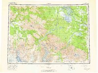 1960 Nabesna1966 Print · USGSEastern Alaska's interior at the dawn of the sixties shows a landscape of remote indigenous villages and highway outposts. Genealogists and historians can locate Northway Indian Village, the Seaton Roadhouse, and mining history at Nabesna.5 unique versions available
End of results
Showing maps 1-5 of 5
Frequently asked questions
- What are the different types of historical maps available for Batzulnetas?
- What is the oldest map of Batzulnetas?
- Where can I purchase historical maps of Batzulnetas for my home or office?
- Where can I download high-res historical maps of Batzulnetas?
- Are there historical topographic maps available for Batzulnetas?
- Is there historical aerial imagery available for Batzulnetas?
- Where are historical maps of Batzulnetas sourced from?