Old Maps of Chokosna, Alaska for Genealogy
Trace your family roots with 6 historic maps of Chokosna. These high-res maps reveal old neighborhoods, homesites, landmarks, and streets — helping you uncover where your ancestors lived and how the area evolved over time.
- Explore historic neighborhoods: Identify where your relatives may have lived in the 1800s or 1900s.
- Compare maps over time: Trace the changes in streets, buildings, and landmarks for multi-generational research.
- Perfect for genealogy & ancestry research: Used by family historians and researchers to map out lineage and migration.
These maps are an incredible resource for exploring your personal connection to Chokosna's past.
Chokosna, AK maps
(6)- 1951 Map of McCarthy
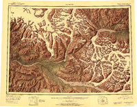 1951 McCarthy1951 Print · USGSThe high Wrangell Mountains and the copper country of the early 1950s are preserved here in detail. Researchers can trace the routes from McCarthy to the Jumbo Mine or explore the massive reaches of the Kennicott Glacier and Chitina River.4 unique versions available
 - 1951 Map of McCarthy B-8, 1964 Print
 1951 McCarthy B-81964 Print · USGSThe Chetina River valley in the early 1950s shows a landscape shaped by glacial waters and early transportation routes. Researchers can trace the Old Railroad Grade past the Gilahina River or locate the solitary Cabin near the Kuskulana.3 unique versions available
 - 1960 Map of McCarthy, 1967 Print
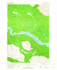
 1960 McCarthy1967 Print · USGSThe Wrangell Mountains and the Alaska-Yukon border are captured here during a period of transition for the region's mining and transportation networks. Researchers can trace the RR line to McCarthy and locate remote outposts like Dan Creek Camp and Chititu Camp.7 unique versions available
 - 1995 Map of McCarthy B-8, 2001 Print
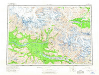
 1995 McCarthy B-82001 Print · USGSCentral Alaska in the mid-twentieth century remains a wilderness defined by its massive river systems and solitary mountain peaks. Researchers can trace the path of the Mc Carthy Road as it passes Gilahina Butte and the wide Chitina River.
 - 2017 Map of McCarthy B-8 NE, 2017 Print
 2017 McCarthy B-8 NE2017 Print · USGSCovers Chokosna, including Unorganized Borough, United States, and other nearby areas
 - 2023 Map of McCarthy B-8 NE, 2023 Print
 2023 McCarthy B-8 NE2023 Print · USGSAlaska's interior wilderness near the Copper River is captured here in the early twenty-first century, showing the intersection of vital waterways and modern access routes. Map enthusiasts can trace the course of the Gilahina River and locate remote landmarks like Gilahina Butte and the Gilahina Trl.
End of results
Showing maps 1-6 of 6
Frequently asked questions
- What are the different types of historical maps available for Chokosna?
- What is the oldest map of Chokosna?
- Where can I purchase historical maps of Chokosna for my home or office?
- Where can I download high-res historical maps of Chokosna?
- Are there historical topographic maps available for Chokosna?
- Is there historical aerial imagery available for Chokosna?
- Where are historical maps of Chokosna sourced from?