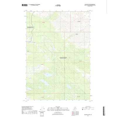
2017 Map of McCarthy B-8 NE
USGS Topo · Published 2017About this map
The Wrangell Mountains dominate this region of interior Alaska, where the landscape is split between the Wrangell-Saint Elias National Park and the Wrangell-Saint Elias National Preserve. A primary artery through this wilderness is the historic McCarthy Road, which winds past the Gilahina Butte as it follows the drainage systems of the Chokosna River and Gilahina River. These glacial-fed waters are joined by smaller tributaries like Dora Cr, forming a complex network of seasonal channels. This 2017 survey provides a precise look at the transition between protected parkland and preserve status, marking specific access points like the Gilahina Trail. Remote water bodies, including Rock Lake and Tooth Lake, are documented within the vast glacial outwash and marshy lowlands typical of the Copper River basin hinterlands.
Find a feature on this map
17 named features on this map. Tap any name to fly to it.
Don’t see what you’re looking for? This feature index may not catch every label — zoom into the map to look around manually.
Map Details
Editions of this 2017 McCarthy B-8 NE Map
This is the sole edition of this map. No revisions or reprints were ever made.
Other maps of this area

1951 · McCarthy
USGS Topo · 1:250,000

1951 · McCarthy C-8
USGS Topo · 1:63,360

1951 · McCarthy B-8
USGS Topo · 1:63,360

1959 · McCarthy C-7
USGS Topo · 1:63,360

1959 · McCarthy B-7
USGS Topo · 1:63,360

1960 · McCarthy
USGS Topo · 1:250,000
1995 · McCarthy B-7
USGS Topo · 1:63,360

1995 · McCarthy B-8
USGS Topo · 1:63,360
1995 · McCarthy C-7
USGS Topo · 1:63,360
1995 · McCarthy C-8
USGS Topo · 1:63,360