
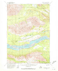
1959 Map of McCarthy B-7
USGS Topo · Published 1966About this map
The Chitina River valley dominates this late 1950s survey, revealing a landscape defined by braided glacial waterways and the remnants of early industrial infrastructure. The presence of the Old Railroad Grade running westward from Long Lake provides a tangible link to the region's transportation history, tracing a path through the valley between the mountain ranges. Small outposts and logistical markers, such as a Cabin and a Landing Strip, indicate the sparse but essential human footprint in the territory during this era.
Find a feature on this map
14 named features on this map. Tap any name to fly to it.
Don’t see what you’re looking for? This feature index may not catch every label — zoom into the map to look around manually.
Map Details
Editions of this 1959 McCarthy B-7 Map
2 editions found
Other maps of this area

1950 · McCarthy A-8
USGS Topo · 1:63,360

1951 · McCarthy
USGS Topo · 1:250,000

1951 · McCarthy C-8
USGS Topo · 1:63,360

1951 · McCarthy B-8
USGS Topo · 1:63,360

1959 · McCarthy B-6
USGS Topo · 1:63,360

1959 · McCarthy A-6
USGS Topo · 1:63,360

1959 · McCarthy C-6
USGS Topo · 1:63,360

1959 · McCarthy A-7
USGS Topo · 1:63,360

1959 · McCarthy C-7
USGS Topo · 1:63,360

1960 · McCarthy
USGS Topo · 1:250,000