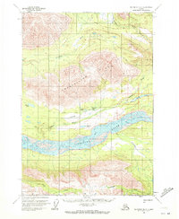
1959 Map of McCarthy B-7
USGS Topo · Published 1972About this map
The Chitina River flows across this Alaskan landscape, defining the topography south of the Crystalline Hills. An Old Railroad Grade runs parallel to the river valley, marking the legacy of earlier industrial transportation through the wilderness near Crystal Creek. The map shows a series of alpine lakes, including Moose Lake, Lakina Lake, and Long Lake, which dot the terrain between the high peaks and the river's braided channels. A single Landing Strip and an isolated Cabin indicate the sparse human footprint in this area during the late 1950s. To the north, the Gilahina River and Lakina River descend from higher elevations, feeding into the main Chitina drainage. This document, based on 1957 aerial photography and 1959 field annotations, reflects a period when many land lines remained unsurveyed and unmarked by the Bureau of Land Management.
Find a feature on this map
15 named features on this map. Tap any name to fly to it.
Don’t see what you’re looking for? This feature index may not catch every label — zoom into the map to look around manually.
Map Details
Editions of this 1959 McCarthy B-7 Map
2 editions found
Other maps of this area

1950 · McCarthy A-8
USGS Topo · 1:63,360

1951 · McCarthy
USGS Topo · 1:250,000

1951 · McCarthy C-8
USGS Topo · 1:63,360

1951 · McCarthy B-8
USGS Topo · 1:63,360

1959 · McCarthy B-6
USGS Topo · 1:63,360

1959 · McCarthy A-6
USGS Topo · 1:63,360

1959 · McCarthy C-6
USGS Topo · 1:63,360

1959 · McCarthy A-7
USGS Topo · 1:63,360

1959 · McCarthy C-7
USGS Topo · 1:63,360

1959 · McCarthy B-7
USGS Topo · 1:63,360