
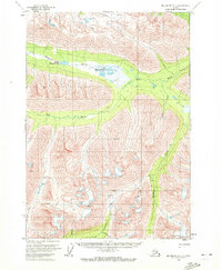
1959 Map of McCarthy A-7
USGS Topo · Published 1966About this map
Hanagita River flows through the northern reaches of this Alaskan interior, connecting the Middle Hanagita Lake and Upper Hanagita Lakes. The landscape is dominated by high glacial terrain and steep drainages, where prospectors and bush pilots operated mid-century. Industry is visible near the center of the sheet, marked by the Yellowband Mine and an associated Aqueduct, reflecting the persistent search for minerals in this drainage basin. To the south, the Bremner Landing Strip served as a critical point of access for this remote area, situated near the confluence of Golconda Creek and Standard Creek. The mapping reveals a network of Trails and isolated Cabin locations that speak to the seasonal life of miners and trappers along Monahan Creek and Gold Creek during the late 1950s.
Find a feature on this map
28 named features on this map. Tap any name to fly to it.
Don’t see what you’re looking for? This feature index may not catch every label — zoom into the map to look around manually.
Map Details
Editions of this 1959 McCarthy A-7 Map
2 editions found
Other maps of this area

1950 · McCarthy A-8
USGS Topo · 1:63,360

1950 · Bering Glacier
USGS Topo · 1:250,000

1951 · McCarthy
USGS Topo · 1:250,000

1951 · Bering Glacier
USGS Topo · 1:250,000

1951 · McCarthy B-8
USGS Topo · 1:63,360

1959 · McCarthy B-6
USGS Topo · 1:63,360

1959 · McCarthy A-6
USGS Topo · 1:63,360

1959 · Bering Glacier
USGS Topo · 1:250,000

1959 · McCarthy B-7
USGS Topo · 1:63,360

1960 · McCarthy
USGS Topo · 1:250,000