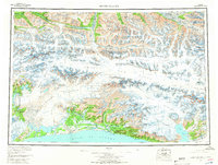
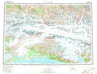
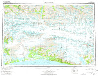
1959 Map of Bering Glacier
USGS Topo · Published 1966About this map
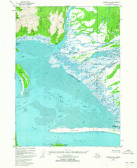
Bagley Ice Field dominates the central landscape of this 1959 survey, a massive glacial expanse hemmed in by the Chugach Mountains and the Saint Elias Mountains. Along the southern coast, the small settlement of Yakataga and the Yakataga Airport serve as the primary human outposts between the Gulf of Alaska and the rising peaks. The map details a transition from the fractured ice of the Bering Glacier to the coastal wetlands around the Suckling River and Tsiu River.
Find a feature on this map
89 named features on this map. Tap any name to fly to it.
Don’t see what you’re looking for? This feature index may not catch every label — zoom into the map to look around manually.
Map Details
Editions of this 1959 Bering Glacier Map
4 editions found

Other maps of this area

1948 · Cordova
USGS Topo · 1:250,000

1948 · Icy Bay D-2 and D-3
USGS Topo · 1:63,360

1948 · Middleton Island
USGS Topo · 1:250,000

1948 · Bering Glacier A-4
USGS Topo · 1:63,360

1950 · Middleton Island
USGS Topo · 1:250,000

1950 · Bering Glacier A-3
USGS Topo · 1:63,360
1950 · McCarthy A-8
USGS Topo · 1:63,360

1950 · Bering Glacier
USGS Topo · 1:250,000

1950 · Icy Bay
USGS Topo · 1:250,000
1950 · Cordova A-1
USGS Topo · 1:63,360