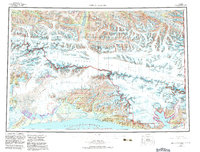
1959 Map of Bering Glacier
USGS Topo · Published 1983About this map
Bagley Ice Field dominates the high alpine landscape of this 1959 survey, serving as the massive frozen reservoir that feeds the Bering Glacier and Steller Glacier. This wilderness, eventually incorporated into the Wrangell-Saint Elias National Park, is defined by its extreme glacial topography and the sheer verticality of the Saint Elias Mountains. Along the coastline, the Robinson Mountains and Dahlgren Ridge separate the ice fields from the Gulf of Alaska, where a solitary Landing Strip near Cape Yakataga represents one of the few signs of human infrastructure.
Find a feature on this map
95 named features on this map. Tap any name to fly to it.
Don’t see what you’re looking for? This feature index may not catch every label — zoom into the map to look around manually.
Map Details
Editions of this 1959 Bering Glacier Map
4 editions found

Other maps of this area

1948 · Cordova
USGS Topo · 1:250,000

1948 · Icy Bay D-2 and D-3
USGS Topo · 1:63,360

1948 · Middleton Island
USGS Topo · 1:250,000

1948 · Bering Glacier A-4
USGS Topo · 1:63,360

1950 · Middleton Island
USGS Topo · 1:250,000

1950 · Bering Glacier A-3
USGS Topo · 1:63,360

1950 · McCarthy A-8
USGS Topo · 1:63,360

1950 · Bering Glacier
USGS Topo · 1:250,000

1950 · Icy Bay
USGS Topo · 1:250,000

1950 · Cordova A-1
USGS Topo · 1:63,360