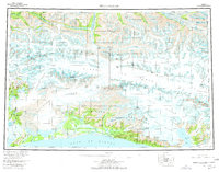
1959 Map of Bering Glacier
USGS Topo · Published 1977About this map
The Bering Glacier dominates this mid-century Alaskan coastal landscape, shown here as a massive ice flow descending toward the Gulf of Alaska. The coastal margin is defined by isolated settlements such as Cape Yakataga and Sunshine Point, which sit between the surf and the rising Robinson Mountains. This 1959 survey records a transition from the dense ice of the Bagley Ice Field and Steller Glacier to the braided river systems of the Kiklukh River and Tashalich River. To the east, the ice-choked waters of Icy Bay separate the Guyot Hills from the Malaspina Glacier. Inland, the topography rises sharply into the Chugach Mountains and the Saint Elias Mountains, where the international boundary separates Alaska from the Yukon. The map provides a detailed view of the glacial drainage patterns, including the Bremner River and the high-altitude Chitina Glacier.
Find a feature on this map
68 named features on this map. Tap any name to fly to it.
Don’t see what you’re looking for? This feature index may not catch every label — zoom into the map to look around manually.
Map Details
Editions of this 1959 Bering Glacier Map
4 editions found

Other maps of this area

1948 · Cordova
USGS Topo · 1:250,000

1948 · Icy Bay D-2 and D-3
USGS Topo · 1:63,360

1948 · Middleton Island
USGS Topo · 1:250,000

1948 · Bering Glacier A-4
USGS Topo · 1:63,360

1950 · Middleton Island
USGS Topo · 1:250,000

1950 · Bering Glacier A-3
USGS Topo · 1:63,360

1950 · McCarthy A-8
USGS Topo · 1:63,360

1950 · Bering Glacier
USGS Topo · 1:250,000

1950 · Icy Bay
USGS Topo · 1:250,000

1950 · Cordova A-1
USGS Topo · 1:63,360