1900s (20th Century) Maps of Christian, Alaska
Explore 3 historic maps of Christian from the 1900s (20th Century). These maps offer a rare glimpse into what life looked like during the 1900s — showing old roads, neighborhoods, homes, and landmarks that have changed or disappeared over time.
Whether you're researching your family's past, planning a metal detecting trip, or studying how Christian's landscape evolved across the 1900s, these high-resolution maps are a powerful tool for exploring the history of this region.
- Focus on a specific era: All maps on this page are from the 1900s, giving you a focused view of this time period.
- See what’s changed: Compare century-old streets, trails, and buildings to today's modern landscape using overlays and satellite layers.
- Research with precision: Use these maps for genealogy, historical research, land use analysis, or educational projects.
- View, download, or print: Maps are fully viewable online in high resolution, and can be downloaded or printed for your own records.
Start exploring Christian's history through authentic maps from the 1900s. This is your window into the past.
Christian, AK maps
(3)- 1951 Map of Christian, 1952 Print
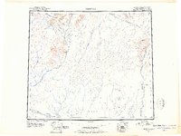 1951 Christian1952 Print · USGSInterior Alaska during the early postwar years reveals a landscape of massive river systems and essential overland routes. Genealogists and historians can trace the early layout of Venetie, follow the Winter Trail, or locate the remote settlement of Christian.2 unique versions available
 - 1956 Map of Christian, 1959 Print
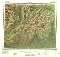 1956 Christian1959 Print · USGSInterior Alaska in the mid-fifties remains a world of remote rivers and seasonal routes through the Venetie Indian Reservation. Researchers can trace the Sled Trail connecting Venetie to the Christian Landing Area and locate many isolated Cabins along the Koness River.7 unique versions available
 - 1990 Map of Christian B-3
 1990 Christian B-31990 Print · USGSThe Alaska interior at the end of the 1970s is documented here as the northern highlands meet the vast Yukon Flats. Researchers can trace the winding Winter Trail and the remote Christian Landing Strip along the banks of the Christian River.
End of results
Showing maps 1-3 of 3
Frequently asked questions
- What are the different types of historical maps available for Christian?
- What is the oldest map of Christian?
- Where can I purchase historical maps of Christian for my home or office?
- Where can I download high-res historical maps of Christian?
- Are there historical topographic maps available for Christian?
- Is there historical aerial imagery available for Christian?
- Where are historical maps of Christian sourced from?