Old Maps of Christian, Alaska for Genealogy
Trace your family roots with 4 historic maps of Christian. These high-res maps reveal old neighborhoods, homesites, landmarks, and streets — helping you uncover where your ancestors lived and how the area evolved over time.
- Explore historic neighborhoods: Identify where your relatives may have lived in the 1800s or 1900s.
- Compare maps over time: Trace the changes in streets, buildings, and landmarks for multi-generational research.
- Perfect for genealogy & ancestry research: Used by family historians and researchers to map out lineage and migration.
These maps are an incredible resource for exploring your personal connection to Christian's past.
Christian, AK maps
(4)- 1951 Map of Christian, 1952 Print
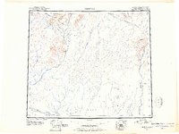 1951 Christian1952 Print · USGSInterior Alaska during the early postwar years reveals a landscape of massive river systems and essential overland routes. Genealogists and historians can trace the early layout of Venetie, follow the Winter Trail, or locate the remote settlement of Christian.2 unique versions available
 - 1956 Map of Christian, 1959 Print
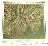 1956 Christian1959 Print · USGSInterior Alaska in the mid-fifties remains a world of remote rivers and seasonal routes through the Venetie Indian Reservation. Researchers can trace the Sled Trail connecting Venetie to the Christian Landing Area and locate many isolated Cabins along the Koness River.7 unique versions available
 - 1990 Map of Christian B-3
 1990 Christian B-31990 Print · USGSThe Alaska interior at the end of the 1970s is documented here as the northern highlands meet the vast Yukon Flats. Researchers can trace the winding Winter Trail and the remote Christian Landing Strip along the banks of the Christian River.
 - 2018 Map of Christian B-3 SE, 2018 Print
 2018 Christian B-3 SE2018 Print · USGSThe northern Yukon-Koyukuk region appears in this 2018 survey as a landscape of winding waterways and isolated settlements. Researchers can trace the path of the Christian River or locate the remote outpost of Christian near Square Lake.
End of results
Showing maps 1-4 of 4
Frequently asked questions
- What are the different types of historical maps available for Christian?
- What is the oldest map of Christian?
- Where can I purchase historical maps of Christian for my home or office?
- Where can I download high-res historical maps of Christian?
- Are there historical topographic maps available for Christian?
- Is there historical aerial imagery available for Christian?
- Where are historical maps of Christian sourced from?