Old Maps of Coldfoot, Alaska for Academic Research
Study the evolution of Coldfoot with 5 high-resolution historic maps. Whether you're teaching, researching, or modeling changes in land use, these maps provide essential visual documentation of urban, environmental, and geographic change.
- Analyze long-term change: Track patterns in development, transportation, and natural features.
- Ideal for environmental or urban studies: Support academic projects with primary historical map data.
- Use in the classroom or lab: Educators and researchers rely on these maps to bring historical context to life.
These maps are a powerful tool for teaching, research, and visualizing how Coldfoot has changed over the decades.
Coldfoot, AK maps
(5)- 1951 Map of Wiseman, 1952 Print
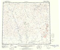 1951 Wiseman1952 Print · USGSThe Central Brooks Range in the early 1950s remained a frontier of isolated mining camps and river corridors. Researchers can trace the layout of Wiseman, Nolan, and Coldfoot, alongside remote landmarks like Pamichtuk Lake and the peaks of the Endicott Mountains.2 unique versions available
 - 1956 Map of Wiseman, 1959 Print
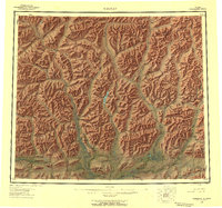 1956 Wiseman1959 Print · USGSThe central Brooks Range and the mining outposts of the Koyukuk valley are documented here in the mid-fifties. Researchers can locate remote cabins, placer mines, and historic landings like Wiseman, Coldfoot, and Tramway Bar along the Koyukuk River.10 unique versions available
 - 1964 Map of Wiseman
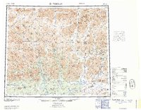 1964 Wiseman1964 Print · USGSThe Koyukuk River wilderness comes into focus in the mid-1950s, highlighting the isolated mining outposts of the Central Brooks Range. Researchers can trace the Tramway Bar Trail and locate historic Placer Mine sites near Wiseman, Nolan, and Coldfoot.
 - 1971 Map of Wiseman B-1, 1974 Print
 1971 Wiseman B-11974 Print · USGSThe northern interior near Wiseman is captured in the early seventies, a landscape still shaped by the gold rush and seasonal river travel. Researchers can trace the Winter Road and find remote sites like the Placer Mine at Nolan and the small Cem near the river.3 unique versions available
 - 2017 Map of Wiseman B-1 SE, 2017 Print
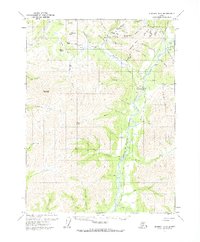
 2017 Wiseman B-1 SE2017 Print · USGSThe northern interior of Alaska comes into focus in this recent survey of the Brooks Range foothills. Trace the industrial corridor of the Alaska Pipeline and Dalton Highway as they bypass the settlement of Coldfoot and the Coldfoot Airport.
End of results
Showing maps 1-5 of 5
Frequently asked questions
- What are the different types of historical maps available for Coldfoot?
- What is the oldest map of Coldfoot?
- Where can I purchase historical maps of Coldfoot for my home or office?
- Where can I download high-res historical maps of Coldfoot?
- Are there historical topographic maps available for Coldfoot?
- Is there historical aerial imagery available for Coldfoot?
- Where are historical maps of Coldfoot sourced from?