Old Maps of Egavik, Alaska for Hiking & Exploration
Hike through history with 5 historic maps of Egavik. Explore old trails, ghost towns, and forgotten backroads — perfect for outdoor adventurers and local explorers.
- Rediscover forgotten places: Map out old mining camps, roads, and footpaths that no longer exist on modern maps.
- Layer with modern tools: Combine with LiDAR or satellite views to plan hikes through historical terrain.
- Made for exploration: Popular among hikers, overlanders, and local history lovers.
Use these maps to find adventure and explore the hidden past of Egavik.
Egavik, AK maps
(5)- 1948 Map of Norton Bay, 1954 Print
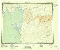 1948 Norton Bay1954 Print · USGSThe eastern shores of Norton Sound are captured here during the late 1940s, highlighting the coastal reservations and inland mountain trails. Trace the old travel routes between Isaac Roadhouse, Egavik, and remote outposts like Old Woman Cabin.2 unique versions available
 - 1950 Map of Norton Bay A-4, 1958 Print
 1950 Norton Bay A-41958 Print · USGSCoastal life along Norton Sound in the early fifties was centered on remote outposts and traditional travel routes. Researchers can trace the path of the Winter Trail as it passes the settlement at Egavik and several lonely Cabin sites.3 unique versions available
 - 1951 Map of Norton Bay
 1951 Norton Bay1951 Print · USGSThe Norton Sound coastline and Kaltag Mountains appear here during the early fifties, documenting a land of vital trail shelters and river corridors. Genealogists and historians can trace the remote network of outposts like Shaktolik Roadhouse, Kwik, and Old Woman Cabin.2 unique versions available
 - 1955 Map of Norton Bay, 1963 Print
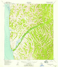
 1955 Norton Bay1963 Print · USGSCoastal life and inland wilderness meet along the Bering Sea in the mid-1950s. Trace old travel routes like the Portage and Trail through the Reindeer Reservation to historic stops like Isaacs Roadhouse and Old Woman Cabin.4 unique versions available
 - 2014 Map of Norton Bay A-4 SW, 2014 Print
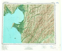
 2014 Norton Bay A-4 SW2014 Print · USGSCoastal life along the Bering Sea is centered at Egavik in the early twenty-first century. Researchers can trace the path of the Shaktolik Road and follow the course of Egavik Cr as it flows toward the eastern reaches of Norton Sound.
End of results
Showing maps 1-5 of 5
Top cities near Egavik
Frequently asked questions
- What are the different types of historical maps available for Egavik?
- What is the oldest map of Egavik?
- Where can I purchase historical maps of Egavik for my home or office?
- Where can I download high-res historical maps of Egavik?
- Are there historical topographic maps available for Egavik?
- Is there historical aerial imagery available for Egavik?
- Where are historical maps of Egavik sourced from?