1950s Maps of Golovin, Alaska
Explore 4 historic maps of Golovin from the 1950s. These maps offer a rare glimpse into what life looked like during the 1950s — showing old roads, neighborhoods, homes, and landmarks that have changed or disappeared over time.
Whether you're researching your family's past, planning a metal detecting trip, or studying how Golovin's landscape evolved across the 1950s, these high-resolution maps are a powerful tool for exploring the history of this region.
- Focus on a specific era: All maps on this page are from the 1950s, giving you a focused view of this time period.
- See what’s changed: Compare century-old streets, trails, and buildings to today's modern landscape using overlays and satellite layers.
- Research with precision: Use these maps for genealogy, historical research, land use analysis, or educational projects.
- View, download, or print: Maps are fully viewable online in high resolution, and can be downloaded or printed for your own records.
Start exploring Golovin's history through authentic maps from the 1950s. This is your window into the past.
Golovin, AK maps
(4)- 1950 Map of Solomon C-2, 1956 Print
 1950 Solomon C-21956 Print · USGSThe Seward Peninsula coast was still defined by its seasonal trails and maritime access during the early fifties. Local researchers can trace early communications via the Telephone Line or locate remote waypoints like the Shelter and Cabins near Golovnin Bay.2 unique versions available
 - 1950 Map of Solomon, 1956 Print
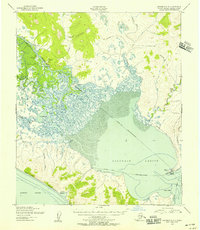
 1950 Solomon1956 Print · USGSThe southern Seward Peninsula is captured here in the mid-1950s, showing a landscape defined by coastal outposts and inland mining camps. Trace historic routes like the Winter Trail or locate the Big Hurrah Mine and Ruby Roadhouse.5 unique versions available
 - 1950 Map of Solomon C-3, 1956 Print
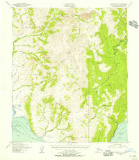
 1950 Solomon C-31956 Print · USGSThe Seward Peninsula at the midpoint of the century shows a landscape of vital river and lagoon transportation. Researchers can trace the mid-century infrastructure of White Mountain, the village of Golovin, and remote outposts like Council Landing.3 unique versions available
 - 1951 Map of Solomon
 1951 Solomon1951 Print · USGSThe Seward Peninsula during the mid-century shows the intricate network of mining trails and coastal outposts that followed the gold rushes. Researchers can trace the Seward Peninsula Railroad and locate interior settlements like Council or the Big Hurrah Mine.3 unique versions available
End of results
Showing maps 1-4 of 4
Frequently asked questions
- What are the different types of historical maps available for Golovin?
- What is the oldest map of Golovin?
- Where can I purchase historical maps of Golovin for my home or office?
- Where can I download high-res historical maps of Golovin?
- Are there historical topographic maps available for Golovin?
- Is there historical aerial imagery available for Golovin?
- Where are historical maps of Golovin sourced from?