1900s (20th Century) Maps of Gustavus, Alaska
Explore 5 historic maps of Gustavus from the 1900s (20th Century). These maps offer a rare glimpse into what life looked like during the 1900s — showing old roads, neighborhoods, homes, and landmarks that have changed or disappeared over time.
Whether you're researching your family's past, planning a metal detecting trip, or studying how Gustavus's landscape evolved across the 1900s, these high-resolution maps are a powerful tool for exploring the history of this region.
- Focus on a specific era: All maps on this page are from the 1900s, giving you a focused view of this time period.
- See what’s changed: Compare century-old streets, trails, and buildings to today's modern landscape using overlays and satellite layers.
- Research with precision: Use these maps for genealogy, historical research, land use analysis, or educational projects.
- View, download, or print: Maps are fully viewable online in high resolution, and can be downloaded or printed for your own records.
Start exploring Gustavus's history through authentic maps from the 1900s. This is your window into the past.
Gustavus, AK maps
(5)- 1948 Map of Juneau B-6, 1956 Print
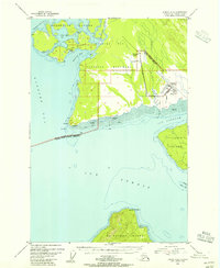 1948 Juneau B-61956 Print · USGSCoastal Alaska at the dawn of the fifties reveals a landscape defined by water and wilderness. Local historians can trace the early infrastructure of Gustavus, from the Gustavus Airfield to landmarks like Bartlett Cove and Pleasant Island.4 unique versions available
 - 1948 Map of Juneau B-5, 1956 Print
 1948 Juneau B-51956 Print · USGSCoastal life in Southeast Alaska at the end of the 1940s centers on the deep waters of Excursion Inlet and the edge of Glacier Bay National Monument. Researchers can find early maritime landmarks like the Aero Light and trace local history at the Indian Cem and Military Cem.
 - 1950 Map of Juneau B-5, 1968 Print
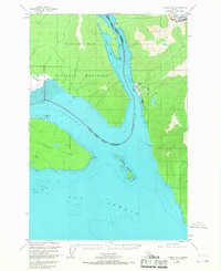 1950 Juneau B-51968 Print · USGSSoutheast Alaska’s coastal wilderness comes into focus in the mid-twentieth century as maritime commerce and federal conservation intersect. Researchers can locate the Cannery at Excursion Inlet and trace heritage sites like the Indian Cem.2 unique versions available
 - 1951 Map of Juneau
 1951 Juneau1951 Print · USGSJuneau and the industrial waterfront of the Gastineau Channel are shown here at the start of the 1950s. Researchers can trace the mid-century footprint of Juneau, the mining history of Treadwell, and remote maritime outposts like Hoonah and Gustavus.4 unique versions available
 - 1962 Map of Juneau, 1966 Print
 1962 Juneau1966 Print · USGSSoutheast Alaska in the early sixties showcases a maritime landscape defined by the Tongass National Forest and the peaks of the Coast Mountains. Trace the footprints of coastal industry at Treadwell, Thane, and the regional hub of Juneau.7 unique versions available
End of results
Showing maps 1-5 of 5
Frequently asked questions
- What are the different types of historical maps available for Gustavus?
- What is the oldest map of Gustavus?
- Where can I purchase historical maps of Gustavus for my home or office?
- Where can I download high-res historical maps of Gustavus?
- Are there historical topographic maps available for Gustavus?
- Is there historical aerial imagery available for Gustavus?
- Where are historical maps of Gustavus sourced from?