Old Maps of Gustavus, Alaska for Academic Research
Study the evolution of Gustavus with 11 high-resolution historic maps. Whether you're teaching, researching, or modeling changes in land use, these maps provide essential visual documentation of urban, environmental, and geographic change.
- Analyze long-term change: Track patterns in development, transportation, and natural features.
- Ideal for environmental or urban studies: Support academic projects with primary historical map data.
- Use in the classroom or lab: Educators and researchers rely on these maps to bring historical context to life.
These maps are a powerful tool for teaching, research, and visualizing how Gustavus has changed over the decades.
Gustavus, AK maps
(11)- 1948 Map of Juneau B-6, 1956 Print
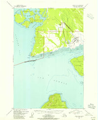 1948 Juneau B-61956 Print · USGSCoastal Alaska at the dawn of the fifties reveals a landscape defined by water and wilderness. Local historians can trace the early infrastructure of Gustavus, from the Gustavus Airfield to landmarks like Bartlett Cove and Pleasant Island.4 unique versions available
 - 1948 Map of Juneau B-5, 1956 Print
 1948 Juneau B-51956 Print · USGSCoastal life in Southeast Alaska at the end of the 1940s centers on the deep waters of Excursion Inlet and the edge of Glacier Bay National Monument. Researchers can find early maritime landmarks like the Aero Light and trace local history at the Indian Cem and Military Cem.
 - 1950 Map of Juneau B-5, 1968 Print
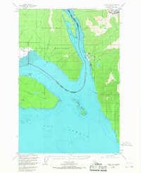 1950 Juneau B-51968 Print · USGSSoutheast Alaska’s coastal wilderness comes into focus in the mid-twentieth century as maritime commerce and federal conservation intersect. Researchers can locate the Cannery at Excursion Inlet and trace heritage sites like the Indian Cem.2 unique versions available
 - 1951 Map of Juneau
 1951 Juneau1951 Print · USGSJuneau and the industrial waterfront of the Gastineau Channel are shown here at the start of the 1950s. Researchers can trace the mid-century footprint of Juneau, the mining history of Treadwell, and remote maritime outposts like Hoonah and Gustavus.4 unique versions available
 - 1962 Map of Juneau, 1966 Print
 1962 Juneau1966 Print · USGSSoutheast Alaska in the early sixties showcases a maritime landscape defined by the Tongass National Forest and the peaks of the Coast Mountains. Trace the footprints of coastal industry at Treadwell, Thane, and the regional hub of Juneau.7 unique versions available
 - 2015 Map of Juneau B-5 NW, 2015 Print
 2015 Juneau B-5 NW2015 Print · USGSCovers Gustavus, including Unorganized Borough, United States, and other nearby areas
 - 2015 Map of Juneau B-6 NE, 2015 Print
 2015 Juneau B-6 NE2015 Print · USGSCovers Gustavus, including Unorganized Borough, United States, and other nearby areas
 - 2017 Map of Juneau B-6 NW, 2017 Print
 2017 Juneau B-6 NW2017 Print · USGSGlacier Bay's coastal wilderness comes into focus in this recent survey of the Hoonah-Angoon region. Researchers can trace the pathways of the Tlingit Trail and Forest Trail as they weave through Glacier Bay National Park near Bartlett Cove.
 - 2019 Map of Juneau B-6 NE, 2019 Print
 2019 Juneau B-6 NE2019 Print · USGSCovers Gustavus, including Unorganized Borough, United States, and other nearby areas
 - 2021 Map of Juneau B-5 NW, 2021 Print
 2021 Juneau B-5 NW2021 Print · USGSThe coastal settlement of Gustavus is captured in the early 2020s, showing the town's interface with the vast Alaskan wilderness. Researchers can trace the local road network including Duck Drive and examine the boundaries of Glacier Bay National Park.
 - 2021 Map of Juneau B-6 NE, 2021 Print
 2021 Juneau B-6 NE2021 Print · USGSThe coastal settlement of Gustavus is captured in this recent survey as it stands between the Salmon River and the waters of Icy Passage. Researchers can trace local landmarks and property access through family-named routes like Grandpa's Farm Road and Owen's Ditch Road.
End of results
Showing maps 1-11 of 11
Frequently asked questions
- What are the different types of historical maps available for Gustavus?
- What is the oldest map of Gustavus?
- Where can I purchase historical maps of Gustavus for my home or office?
- Where can I download high-res historical maps of Gustavus?
- Are there historical topographic maps available for Gustavus?
- Is there historical aerial imagery available for Gustavus?
- Where are historical maps of Gustavus sourced from?