Old Maps of Hobart Bay, Alaska
Explore 7 old maps of Hobart Bay, spanning from 1948 to today. These high-resolution historic maps reveal how streets, neighborhoods, landmarks, and natural features evolved over time — perfect for genealogy, metal detecting, research, and local history exploration.
What you can do with these maps:
- See how Hobart Bay changed over time: Compare historical maps to modern-day views to trace roads, homesites, rail lines & more.
- View detailed metadata: Each map includes creators, publishers, year, scale, and archive source.
- Overlay maps with satellite & LiDAR: Visualize the past alongside modern tools to explore terrain & human change.
- Trusted historical sources: Maps sourced from the USGS, Library of Congress, and other archives.
- Access maps your way: View online, download high-res files, or order prints for personal or research use.
Start exploring old maps of Hobart Bay to uncover forgotten places, hidden landmarks, and the deep history beneath your feet.
Hobart Bay, AK maps
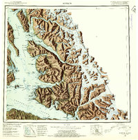
(7)- 1948 Map of Sumdum B-5, 1957 Print
 1948 Sumdum B-51957 Print · USGSSoutheast Alaska's maritime and mining frontiers are captured here just after the war, showing a rugged coastline tied together by lighthouses and relay stations. Researchers can find remote infrastructure like the Five Finger Lighthouse, the K and D Mine, and several isolated Cabins along the shores of Hobart Bay.
 - 1951 Map of Sumdum B-5, 1974 Print
 1951 Sumdum B-51974 Print · USGSSoutheast Alaska in the early fifties was a frontier of maritime trade and remote mining. Historians can locate isolated outposts like the CAA Relay Station and maritime landmarks including the Five Finger Lighthouse and K and D Mine.
 - 1952 Map of Sumdum, 1953 Print
 1952 Sumdum1953 Print · USGSSoutheast Alaska in the early fifties was a land of tidewater glaciers and isolated mining outposts. Researchers can trace the layout of remote coastal settlements like Windham and Sumdum or locate the historic Chuck Mining Camp near Endicott Arm.6 unique versions available
 - 1961 Map of Sumdum, 1967 Print
 1961 Sumdum1967 Print · USGSThe coastal wilderness of Southeast Alaska is captured here in the mid-twentieth century, showing a landscape defined by deep fjords and isolated maritime outposts. Researchers can trace early settlements and navigation aids like Windham, Jamestown, and the Five Finger Lighthouse.2 unique versions available
 - 1996 Map of Sumdum B-5, 2000 Print
 1996 Sumdum B-52000 Print · USGSThe Alexander Archipelago in the mid-1990s shows a complex network of coastal logging and wilderness preservation. You can trace maritime history at the Five Finger Lighthouse or locate industrial sites like the K and D Mine and Logging Camp.
 - 2017 Map of Sumdum B-5 NE, 2017 Print
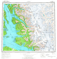
 2017 Sumdum B-5 NE2017 Print · USGSCovers Hobart Bay, including Unorganized Borough, United States, and other nearby areas
 - 2021 Map of Sumdum B-5 NE, 2021 Print
 2021 Sumdum B-5 NE2021 Print · USGSCoastal wilderness and maritime navigation points define this modern survey of the Alexander Archipelago. Researchers can trace the jagged shoreline from Point Hobart to the unique tidal area of The Salt Chuck and Entrance Island.
End of results
Showing maps 1-7 of 7
Frequently asked questions
- What are the different types of historical maps available for Hobart Bay?
- What is the oldest map of Hobart Bay?
- Where can I purchase historical maps of Hobart Bay for my home or office?
- Where can I download high-res historical maps of Hobart Bay?
- Are there historical topographic maps available for Hobart Bay?
- Is there historical aerial imagery available for Hobart Bay?
- Where are historical maps of Hobart Bay sourced from?