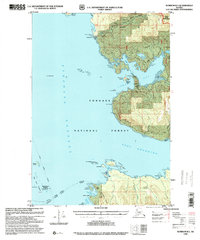
1996 Map of Sumdum B-5
USGS Topo · Published 2000About this map
Tongass National Forest dominates this Alaskan coastal reach, where the deep waters of Stephens Passage meet the intricate inlets of Hobart Bay and Port Houghton. The landscape reflects a mid-1990s intersection of industrial activity and federal preservation, notably the Chuck River Wilderness and the presence of a Logging Camp and multiple Log Transfer Facility sites. Navigational markers such as the Lighthouse Reserve Five Finger Helispot Lighthouse at The Five Fingers underscore the maritime importance of these passages. Inland, the terrain rises toward the Fanshaw Range, while evidence of earlier mineral exploration remains at the K and D Mine. The inclusion of the CAA Relay Station (Ruins) near Rocky Point provides a specific point of interest for those tracing the history of telecommunications and aviation infrastructure in this remote archipelago.
Find a feature on this map
44 named features on this map. Tap any name to fly to it.
Don’t see what you’re looking for? This feature index may not catch every label — zoom into the map to look around manually.
Map Details
Editions of this 1996 Sumdum B-5 Map
This is the sole edition of this map. No revisions or reprints were ever made.
Other maps of this area

1943 · Sumdum B-4
USGS Topo · 1:63,360

1948 · Sumdum A-4
USGS Topo · 1:63,360

1948 · Sumdum A-5
USGS Topo · 1:63,360

1948 · Sumdum C-5
USGS Topo · 1:63,360

1948 · Sumdum A-6
USGS Topo · 1:63,360

1948 · Sumdum B-6
USGS Topo · 1:63,360

1948 · Sumdum C-6
USGS Topo · 1:63,360

1948 · Sumdum B-5
USGS Topo · 1:63,360

1948 · Sumdum B-4
USGS Topo · 1:63,360

1951 · Sumdum C-5
USGS Topo · 1:63,360