1950s Maps of Hooper Bay, Alaska
Explore 5 historic maps of Hooper Bay from the 1950s. These maps offer a rare glimpse into what life looked like during the 1950s — showing old roads, neighborhoods, homes, and landmarks that have changed or disappeared over time.
Whether you're researching your family's past, planning a metal detecting trip, or studying how Hooper Bay's landscape evolved across the 1950s, these high-resolution maps are a powerful tool for exploring the history of this region.
- Focus on a specific era: All maps on this page are from the 1950s, giving you a focused view of this time period.
- See what’s changed: Compare century-old streets, trails, and buildings to today's modern landscape using overlays and satellite layers.
- Research with precision: Use these maps for genealogy, historical research, land use analysis, or educational projects.
- View, download, or print: Maps are fully viewable online in high resolution, and can be downloaded or printed for your own records.
Start exploring Hooper Bay's history through authentic maps from the 1950s. This is your window into the past.
Hooper Bay, AK maps
(5)- 1951 Map of Hooper Bay
 1951 Hooper Bay1951 Print · USGSThe Yukon-Kuskokwim Delta coast is captured here just after the war, showing the remote settlements and river systems of the Bering Sea. You can trace the Winter Trail between Scammon Bay and Kutmiut or locate the old landing at Hooper Bay.
 - 1952 Map of Hooper Bay C-4, 1959 Print
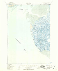
 1952 Hooper Bay C-41959 Print · USGSThe remote Alaskan coast at the start of the 1950s reveals a wild interface of sea and sand. Trace the shifting shoreline of Panowat Spit and find unique coastal markers like the wreck and the winding Manayagvik Slough.2 unique versions available
 - 1952 Map of Hooper Bay B-3, 1959 Print
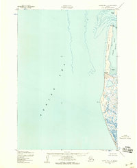
 1952 Hooper Bay B-31959 Print · USGSCoastal Alaska in the early fifties was a land of shifting tides and intricate waterways along the Bering Sea. Researchers can trace the complex drainage of Painoroyun Slough and Issortulik Slough near the prominent Nuok Spit.3 unique versions available
 - 1952 Map of Hooper Bay C-3, 1959 Print
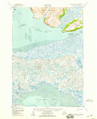 1952 Hooper Bay C-31959 Print · USGSCoastal Alaska in the early fifties is defined here by the intricate delta landscape of Igiak Bay and the village of Hooper Bay. Researchers can trace old coastal infrastructure and sites including the settlement at Paimiut, a cemetery, and the Nuok Spit coastline.3 unique versions available
 - 1953 Map of Hooper Bay, 1963 Print
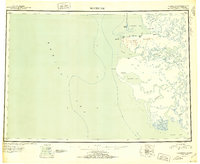
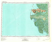 1953 Hooper Bay1963 Print · USGSThe Bering Sea coast near the Yukon-Kuskokwim Delta appears here in the early fifties, showing a land of tidal rivers and tundra. Trace the locations of Hooper Bay, Chevak, and Old Chevak alongside the prominent As Kinuk Mountains.5 unique versions available
End of results
Showing maps 1-5 of 5
Frequently asked questions
- What are the different types of historical maps available for Hooper Bay?
- What is the oldest map of Hooper Bay?
- Where can I purchase historical maps of Hooper Bay for my home or office?
- Where can I download high-res historical maps of Hooper Bay?
- Are there historical topographic maps available for Hooper Bay?
- Is there historical aerial imagery available for Hooper Bay?
- Where are historical maps of Hooper Bay sourced from?