Old Maps of Igushik, Alaska for Hiking & Exploration
Hike through history with 6 historic maps of Igushik. Explore old trails, ghost towns, and forgotten backroads — perfect for outdoor adventurers and local explorers.
- Rediscover forgotten places: Map out old mining camps, roads, and footpaths that no longer exist on modern maps.
- Layer with modern tools: Combine with LiDAR or satellite views to plan hikes through historical terrain.
- Made for exploration: Popular among hikers, overlanders, and local history lovers.
Use these maps to find adventure and explore the hidden past of Igushik.
Igushik, AK maps
(6)- 1945 Map of Nushagak Bay, 1954 Print
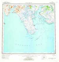
 1945 Nushagak Bay1954 Print · USGSNushagak Bay and the sprawling Alaskan coastline are captured in the mid-1940s, highlighting a landscape defined by salmon fishing and tidal waters. Researchers can locate remote outposts like Old Saltery, the busy Nushagak Cannery, and the coastal settlement of Clarks Point.
 - 1949 Map of Nushagak Bay
 1949 Nushagak Bay1949 Print · USGSCoastal Alaska at the height of the mid-century salmon industry reveals a landscape of isolated canneries and subsistence camps. You can trace the shorelines to find sites like Nushagak Cannery, the Old Saltery, and the remote Igushik Cannery along the river.2 unique versions available
 - 1950 Map of Nushagak Bay C-3, 1955 Print
 1950 Nushagak Bay C-31955 Print · USGSThe eastern coast of the Nushagak Peninsula in the mid-twentieth century reveals a land of tidal rivers and shifting spits. Researchers can locate the historical Igushik (Site) and trace the coastal topography of Nichols Spit and the Nichols Hills.2 unique versions available
 - 1951 Map of Nushagak Bay, 1955 Print
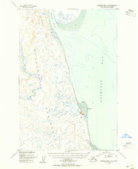
 1951 Nushagak Bay1955 Print · USGSBristol Bay's eastern coastline is captured here in the early fifties, highlighting the salmon fishing and canning hubs of the era. Genealogists and historians can trace coastal settlements like Ekuk and Nushagak or locate the Igushik (Site).7 unique versions available
 - 1964 Map of Nushagak Bay
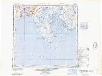 1964 Nushagak Bay1964 Print · USGSNushagak Bay and the Bristol Bay coastline appear in mid-century detail, capturing the seasonal fishing hubs and maritime hazards of the era. Researchers can trace historic cannery sites, coastal settlements like Ekuk, and the shifting sands of Ship Channel or Etolin Pt.
 - 2019 Map of Nushagak Bay C-3 NW, 2019 Print
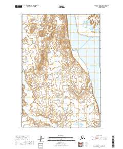 2019 Nushagak Bay C-3 NW2019 Print · USGSNushagak Bay and the Igushik River delta are captured here in the early twenty-first century. Researchers can trace the coastal geography near Igushik, the elevation of Igushik Ridge, and the winding path of the Tunuing River.
End of results
Showing maps 1-6 of 6
Frequently asked questions
- What are the different types of historical maps available for Igushik?
- What is the oldest map of Igushik?
- Where can I purchase historical maps of Igushik for my home or office?
- Where can I download high-res historical maps of Igushik?
- Are there historical topographic maps available for Igushik?
- Is there historical aerial imagery available for Igushik?
- Where are historical maps of Igushik sourced from?