Old Maps of Itulilik, Alaska for Academic Research
Study the evolution of Itulilik with 4 high-resolution historic maps. Whether you're teaching, researching, or modeling changes in land use, these maps provide essential visual documentation of urban, environmental, and geographic change.
- Analyze long-term change: Track patterns in development, transportation, and natural features.
- Ideal for environmental or urban studies: Support academic projects with primary historical map data.
- Use in the classroom or lab: Educators and researchers rely on these maps to bring historical context to life.
These maps are a powerful tool for teaching, research, and visualizing how Itulilik has changed over the decades.
Itulilik, AK maps
(4)- 1950 Map of Sleetmute
 1950 Sleetmute1950 Print · USGSThe Kuskokwim River corridor in the 1950s was a hub of interior Alaskan trade, where commerce relied on seasonal waterways and winter trails. Researchers can trace historic river outposts like Mellicks Trading Post, the Iditarod Winter Trail, and the remnants of Kolmakof Fort (Ruins).2 unique versions available
 - 1954 Map of Sleetmute, 1967 Print
 1954 Sleetmute1967 Print · USGSThe Kuskokwim River corridor in the mid-1950s reveals a network of trade sites and riverside villages between the Horn and Chuilnuk Mountains. Genealogists and researchers can locate remote outposts like Mellicks Trading Post, Red Devil, and the former Kolmakof village site.2 unique versions available
 - 1954 Map of Sleetmute B-3, 1968 Print
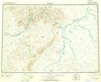
 1954 Sleetmute B-31968 Print · USGSSouthwestern Alaska in the mid-1950s was a land defined by winding river systems and isolated outposts like Cotton Village. Genealogists and historians can trace the paths of the Winter Trail and Tractor Trail as they connect the Hoholitna River to Itulilik.
 - 2019 Map of Sleetmute B-3 NW, 2019 Print
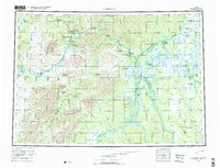
 2019 Sleetmute B-3 NW2019 Print · USGSThe interior of the Bethel Census Area is captured here in the late 2010s, showing a landscape shaped entirely by the shifting waters of the Holitna River. Map collectors and researchers can trace the intricate meander patterns and wetlands around Itulilik Cr.
End of results
Showing maps 1-4 of 4
Frequently asked questions
- What are the different types of historical maps available for Itulilik?
- What is the oldest map of Itulilik?
- Where can I purchase historical maps of Itulilik for my home or office?
- Where can I download high-res historical maps of Itulilik?
- Are there historical topographic maps available for Itulilik?
- Is there historical aerial imagery available for Itulilik?
- Where are historical maps of Itulilik sourced from?