Old Maps of Kanapak, Alaska for Genealogy
Trace your family roots with 4 historic maps of Kanapak. These high-res maps reveal old neighborhoods, homesites, landmarks, and streets — helping you uncover where your ancestors lived and how the area evolved over time.
- Explore historic neighborhoods: Identify where your relatives may have lived in the 1800s or 1900s.
- Compare maps over time: Trace the changes in streets, buildings, and landmarks for multi-generational research.
- Perfect for genealogy & ancestry research: Used by family historians and researchers to map out lineage and migration.
These maps are an incredible resource for exploring your personal connection to Kanapak's past.
Kanapak, AK maps
(4)- 1951 Map of Marshall
 1951 Marshall1951 Print · USGSThe Yukon River corridor and its surrounding delta wetlands are documented here in the early fifties, showcasing the vital riverine economy of the day. Researchers can trace remote settlements and points of interest like Pilot Station, Marshall, and Owl Village.
 - 1952 Map of Marshall D-4, 1964 Print
 1952 Marshall D-41964 Print · USGSThe Yukon delta region in the early fifties reveals a complex landscape of winding waterways and seasonal overland routes. Researchers can trace the shifting course of the Yukon River past Goose Island and follow the remote Winter Trail.2 unique versions available
 - 1954 Map of Marshall, 1966 Print
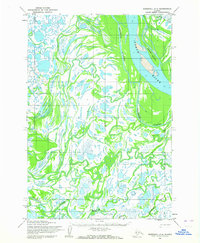
 1954 Marshall1966 Print · USGSThe Yukon Delta and lower river system appear in intricate detail during the mid-fifties, showing the essential water routes and riverfront settlements of the era. Genealogists and researchers can locate Marshall (Fortuna Ledge PO), Pilot Station, and the seasonal Winter Trail crossing the frozen landscape.3 unique versions available
 - 2020 Map of Marshall D-4 SE, 2020 Print
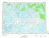
 2020 Marshall D-4 SE2020 Print · USGSThe subarctic wetlands of the Yukon Delta are captured here in the early twenty-first century. Researchers can trace the winding course of the Kashunuk River and locate the remote settlement of Kanapak near Mankakuk Cr.
End of results
Showing maps 1-4 of 4
Top cities near Kanapak
Frequently asked questions
- What are the different types of historical maps available for Kanapak?
- What is the oldest map of Kanapak?
- Where can I purchase historical maps of Kanapak for my home or office?
- Where can I download high-res historical maps of Kanapak?
- Are there historical topographic maps available for Kanapak?
- Is there historical aerial imagery available for Kanapak?
- Where are historical maps of Kanapak sourced from?