Old Maps of Kwethluk, Alaska for Genealogy
Trace your family roots with 5 historic maps of Kwethluk. These high-res maps reveal old neighborhoods, homesites, landmarks, and streets — helping you uncover where your ancestors lived and how the area evolved over time.
- Explore historic neighborhoods: Identify where your relatives may have lived in the 1800s or 1900s.
- Compare maps over time: Trace the changes in streets, buildings, and landmarks for multi-generational research.
- Perfect for genealogy & ancestry research: Used by family historians and researchers to map out lineage and migration.
These maps are an incredible resource for exploring your personal connection to Kwethluk's past.
Kwethluk, AK maps
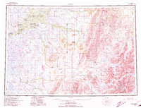
(5)- 1950 Map of Bethel
 1950 Bethel1950 Print · USGSThe Kuskokwim River region in the mid-twentieth century reveals a landscape of remote riverside villages and emerging aviation hubs. Researchers can trace traditional routes like the Winter Trail and locate family-named peaks such as Fisher Dome and Gemuk Mtn.3 unique versions available
 - 1954 Map of Bethel D-7, 1965 Print
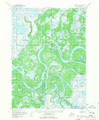 1954 Bethel D-71965 Print · USGSThe Yukon-Kuskokwim Delta in the mid-fifties is a labyrinth of shifting channels and riverside villages. Researchers can locate traditional settlements like Akiachak and Kwethluk or trace the intricate wetlands surrounding Kuskokuak Slough and Kiktak Is.3 unique versions available
 - 1980 Map of Bethel
 1980 Bethel1980 Print · USGSThe Kuskokwim Delta and its riverbank villages are shown here in the early eighties as they relied on the water for transport and trade. Researchers can trace the layout of settlements like Bethel and Kwethluk or explore the wilderness around Chikuminuk Lake and Shining Dome.4 unique versions available
 - 2017 Map of Bethel D-7 SE, 2017 Print
 2017 Bethel D-7 SE2017 Print · USGSThe braided delta of the Bethel region is documented here in the late twenty-tens, showing the critical water routes of the Yukon-Kuskokwim Delta. Researchers can trace the layout of Kwethluk and the paths of Old Airport Road and the Kuskokuak Slough.
 - 2017 Map of Bethel D-7 SW, 2017 Print
 2017 Bethel D-7 SW2017 Print · USGSThe Kuskokwim Delta in the late 2010s is revealed as a labyrinth of shifting waterways and remote aviation outposts. Researchers can trace the winding paths of the Kuskokwim River and Kuskokuak Slough or locate the Kwethluk Airport.
End of results
Showing maps 1-5 of 5
Top cities near Kwethluk
Top neighborhoods of Kwethluk
Frequently asked questions
- What are the different types of historical maps available for Kwethluk?
- What is the oldest map of Kwethluk?
- Where can I purchase historical maps of Kwethluk for my home or office?
- Where can I download high-res historical maps of Kwethluk?
- Are there historical topographic maps available for Kwethluk?
- Is there historical aerial imagery available for Kwethluk?
- Where are historical maps of Kwethluk sourced from?