Old Maps of Marshall, Alaska for Hiking & Exploration
Hike through history with 5 historic maps of Marshall. Explore old trails, ghost towns, and forgotten backroads — perfect for outdoor adventurers and local explorers.
- Rediscover forgotten places: Map out old mining camps, roads, and footpaths that no longer exist on modern maps.
- Layer with modern tools: Combine with LiDAR or satellite views to plan hikes through historical terrain.
- Made for exploration: Popular among hikers, overlanders, and local history lovers.
Use these maps to find adventure and explore the hidden past of Marshall.
Marshall, AK maps
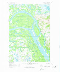
(5)- 1951 Map of Marshall
 1951 Marshall1951 Print · USGSThe Yukon River corridor and its surrounding delta wetlands are documented here in the early fifties, showcasing the vital riverine economy of the day. Researchers can trace remote settlements and points of interest like Pilot Station, Marshall, and Owl Village.
 - 1952 Map of Marshall D-1, 1963 Print
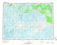
 1952 Marshall D-11963 Print · USGSThe Yukon River flows through this remote Alaskan stretch in the early fifties, revealing a landscape shaped by water and winter travel. Researchers can trace the settlement at Marshall (Fortuna Ledge PO) and find old trails near Takshak and Pilcher Mountain.3 unique versions available
 - 1954 Map of Marshall, 1966 Print
 1954 Marshall1966 Print · USGSThe Yukon Delta and lower river system appear in intricate detail during the mid-fifties, showing the essential water routes and riverfront settlements of the era. Genealogists and researchers can locate Marshall (Fortuna Ledge PO), Pilot Station, and the seasonal Winter Trail crossing the frozen landscape.3 unique versions available
 - 2018 Map of Marshall D-1 SE, 2018 Print
 2018 Marshall D-1 SE2018 Print · USGSThe Yukon River delta region comes into focus in this late twenty-tens survey, revealing the remote settlement patterns and water-driven geography of coastal Alaska. Researchers can trace the landing at Ingrihak or the infrastructure around Marshall Don Hunter Sr Airport and Arbor Island.
 - 2018 Map of Marshall D-1 NE, 2018 Print
 2018 Marshall D-1 NE2018 Print · USGSThe Yukon River valley in the early twenty-first century reveals a landscape of shifting channels and riverfront settlements. Map out the braided paths of Five Day Slough and Monarch Slough or locate local landmarks like Takshak and the heights of Pilcher Mtn.
End of results
Showing maps 1-5 of 5
Frequently asked questions
- What are the different types of historical maps available for Marshall?
- What is the oldest map of Marshall?
- Where can I purchase historical maps of Marshall for my home or office?
- Where can I download high-res historical maps of Marshall?
- Are there historical topographic maps available for Marshall?
- Is there historical aerial imagery available for Marshall?
- Where are historical maps of Marshall sourced from?