Old Maps of Mekoryuk, Alaska for Academic Research
Study the evolution of Mekoryuk with 8 high-resolution historic maps. Whether you're teaching, researching, or modeling changes in land use, these maps provide essential visual documentation of urban, environmental, and geographic change.
- Analyze long-term change: Track patterns in development, transportation, and natural features.
- Ideal for environmental or urban studies: Support academic projects with primary historical map data.
- Use in the classroom or lab: Educators and researchers rely on these maps to bring historical context to life.
These maps are a powerful tool for teaching, research, and visualizing how Mekoryuk has changed over the decades.
Mekoryuk, AK maps
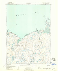
(8)- 1951 Map of Nunivak Island
 1951 Nunivak Island1951 Print · USGSNunivak Island and the eastern Bering Sea coast appear here in the early fifties, showing a remote landscape of subsistence settlements and wildlife refuge lands. Researchers can trace historic sites like Mekoryuk, Kigoumiut, and the Nash Harbor Landing Area.
 - 1952 Map of Nunivak Island B-4, 1958 Print
 1952 Nunivak Island B-41958 Print · USGSNunivak Island's northern coastline and the settlement of Mekoryuk are documented here in the early fifties. Researchers can trace traditional land use through labeled seasonal sites like Summer Camp and Ahkitook (Summer Camp) or the portage paths near Nanwakshak Lake.2 unique versions available
 - 1954 Map of Nunivak Island, 1961 Print
 1954 Nunivak Island1961 Print · USGSNunivak Island and the adjacent Etolin Strait are documented in the mid-1950s, showing a traditional landscape of coastal camps and settlements. Researchers can locate established sites like Mekoryuk and Tanunak or trace seasonal camps at Nash Harbor and Kuvloniut.4 unique versions available
 - 1958 Map of Nunivak Island
 1958 Nunivak Island1958 Print · USGSNunivak Island and Nelson Island appear in the mid-1950s as a series of remote coastal outposts and wildlife habitats. Researchers can locate seasonal camps and landing sites like Nash Harbor, the settlement of Mekoryuk, and landmarks like Cape Mohican.
 - 1964 Map of Nunivak Island
 1964 Nunivak Island1964 Print · USGSNunivak Island and the Bering Sea coast appear here during the mid-1960s, documenting a landscape of traditional Indigenous settlements and federal wildlife refuges. Researchers can locate seasonal camp sites like Luktukukwik and major landmarks including Mekoryuk and the Cape Mohican Light.
 - 2020 Map of Nunivak Island B-4 SE, 2020 Print
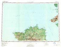
 2020 Nunivak Island B-4 SE2020 Print · USGSNunivak Island's northern coast is documented here in the early twenty-first century, centered on the community of Mekoryuk. Researchers can trace the path of the Mekoryuk River and locate local landmarks like Mekoryuk Airport and the Kimikthak Hills.
 - 2020 Map of Nunivak Island B-4 SW, 2020 Print
 2020 Nunivak Island B-4 SW2020 Print · USGSNunivak Island in the early twenty-first century reveals a coastal landscape shaped by tundra streams and distinctive volcanic elevations. Researchers can trace the drainages of Akituk Cr and Anluk Cr toward landmarks like Ingriruk Hill and the Kimijooksuk Buttes.
 - 2020 Map of Nunivak Island B-4 NE, 2020 Print
 2020 Nunivak Island B-4 NE2020 Print · USGSNunivak Island and the Bering Sea coastline appear in this modern survey of Alaska's maritime landscape. Trace the coastal geography around Cape Etolin and Etolin Bay, and follow local routes like Old Airport Road near the Mekoryuk River.
End of results
Showing maps 1-8 of 8
Top cities near Mekoryuk
Top neighborhoods of Mekoryuk
Frequently asked questions
- What are the different types of historical maps available for Mekoryuk?
- What is the oldest map of Mekoryuk?
- Where can I purchase historical maps of Mekoryuk for my home or office?
- Where can I download high-res historical maps of Mekoryuk?
- Are there historical topographic maps available for Mekoryuk?
- Is there historical aerial imagery available for Mekoryuk?
- Where are historical maps of Mekoryuk sourced from?