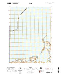
2020 Map of Nunivak Island B-4 NE
USGS Topo · Published 2020About this map
Cape Etolin and the surrounding coastline of Nunivak Island define this 2020 coastal study. The map documents a sparsely populated but geographically distinct landscape where Etolin Bay meets the waters of the Bering Sea. To the south, the Mekoryuk River flows toward Shoal Bay, marking the southern extent of this quadrangle. The terrain is characterized by the Ooklik Dunes, a prominent coastal formation that shifts along the eastern shore. Transportation infrastructure is minimal, consisting primarily of Airport Way and Old Airport Road, which suggest proximity to local aviation facilities serving this remote part of the Bethel Census Area. The absence of traditional towns or industrial centers highlights the subsistence-oriented and natural character of this maritime environment.
Find a feature on this map
12 named features on this map. Tap any name to fly to it.
Don’t see what you’re looking for? This feature index may not catch every label — zoom into the map to look around manually.
Map Details
Editions of this 2020 Nunivak Island B-4 NE Map
This is the sole edition of this map. No revisions or reprints were ever made.
Other maps of this area

1951 · Nunivak Island
USGS Topo · 1:250,000
1952 · Nunivak Island B-3
USGS Topo · 1:63,360
1952 · Nunivak Island B-4
USGS Topo · 1:63,360

1954 · Nunivak Island
USGS Topo · 1:250,000

1958 · Nunivak Island
USGS Topo · 1:250,000

1964 · Nunivak Island
USGS Topo · 1:250,000
2020 · Nunivak Island B-3 SW
USGS Topo · 1:25,000
2020 · Nunivak Island B-3 NW
USGS Topo · 1:25,000
2020 · Nunivak Island B-4 SE
USGS Topo · 1:25,000
2020 · Nunivak Island B-4 SW
USGS Topo · 1:25,000