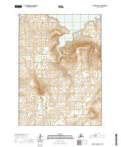
2020 Map of Nunivak Island B-4 SW
USGS Topo · Published 2020About this map
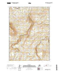
Bering Sea tides meet the coastal tundra of Nunivak Island in this recent survey of the Bethel Census Area. The landscape is defined by the subtle elevations of Kiolik Hill, Ingriruk Hill, and the prominent Kimijooksuk Buttes to the southeast. Multiple drainage systems, including Akituk Cr, Anluk Cr, and Icluwagk Cr, wind through the interior before reaching the jagged northern coastline. At the edge of the sea, the land terminates at Nuaksyalik Point, framing the sheltered waters of Tooksookwat Bay and Kangeekikthluk Cove. This sheet documents a region of Alaska where traditional place-naming persists across a terrain of wetlands and isolated volcanic features, offering an exact record of the island's hydrography and topography.
Find a feature on this map
16 named features on this map. Tap any name to fly to it.
Don’t see what you’re looking for? This feature index may not catch every label — zoom into the map to look around manually.
Map Details
Editions of this 2020 Nunivak Island B-4 SW Map
This is the sole edition of this map. No revisions or reprints were ever made.
Other maps of this area

1951 · Nunivak Island
USGS Topo · 1:250,000

1952 · Nunivak Island A-4
USGS Topo · 1:63,360

1952 · Nunivak Island A-5
USGS Topo · 1:63,360
1952 · Nunivak Island B-5
USGS Topo · 1:63,360
1952 · Nunivak Island B-4
USGS Topo · 1:63,360

1954 · Nunivak Island
USGS Topo · 1:250,000

1958 · Nunivak Island
USGS Topo · 1:250,000

1964 · Nunivak Island
USGS Topo · 1:250,000
2020 · Nunivak Island B-5 NE
USGS Topo · 1:25,000
2020 · Nunivak Island B-4 SE
USGS Topo · 1:25,000