Old Maps of Nikolski, Alaska for Genealogy
Trace your family roots with 3 historic maps of Nikolski. These high-res maps reveal old neighborhoods, homesites, landmarks, and streets — helping you uncover where your ancestors lived and how the area evolved over time.
- Explore historic neighborhoods: Identify where your relatives may have lived in the 1800s or 1900s.
- Compare maps over time: Trace the changes in streets, buildings, and landmarks for multi-generational research.
- Perfect for genealogy & ancestry research: Used by family historians and researchers to map out lineage and migration.
These maps are an incredible resource for exploring your personal connection to Nikolski's past.
Nikolski, AK maps
(3)- 1951 Map of Samalga Island, 1952 Print
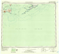 1951 Samalga Island1952 Print · USGSThe southwestern Aleutians are documented here in the early fifties, focusing on the remote settlement of Nikolski. Researchers can trace the volcanic landscape of Chuginadak Island and coastal features like Umnak Lake or Traders Cove.4 unique versions available
 - 1958 Map of Samalga Island
 1958 Samalga Island1958 Print · USGSThe western Aleutians in the late fifties reveal a remote landscape of volcanic peaks and isolated outposts. Trace the small settlement at Nikolski and geographic landmarks like Mt Cleveland and the distant Samalga Island.
 - 2021 Map of Samalga Island D-3 NW, 2021 Print
 2021 Samalga Island D-3 NW2021 Print · USGSUmnak Island and the surrounding Aleutian waters are captured here in the early twenty-first century. Researchers can trace indigenous land names alongside twentieth-century infrastructure like the Nikolski Air Station and landmarks such as High Hill and Rudisell Reef.
End of results
Showing maps 1-3 of 3
Frequently asked questions
- What are the different types of historical maps available for Nikolski?
- What is the oldest map of Nikolski?
- Where can I purchase historical maps of Nikolski for my home or office?
- Where can I download high-res historical maps of Nikolski?
- Are there historical topographic maps available for Nikolski?
- Is there historical aerial imagery available for Nikolski?
- Where are historical maps of Nikolski sourced from?