Old Maps of Nikolski, Alaska for Metal Detecting
Plan your next treasure hunt with 3 historic maps of Nikolski. Find old homesites, ghost towns, trails, and gathering spots that may be lost to time — perfect for identifying promising metal detecting locations.
- Locate forgotten sites: Uncover places like long-lost settlements, abandoned rail lines, or gathering spots.
- Plan better hunts: Use map overlays combined with LiDAR or satellite views to narrow in on historically rich areas.
- Made for detectorists: Thousands of hobbyists use these maps to discover relics, coins, and hidden history.
Use these historic maps to boost your research and find new opportunities beneath the surface of Nikolski.
Nikolski, AK maps
(3)- 1951 Map of Samalga Island, 1952 Print
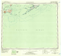 1951 Samalga Island1952 Print · USGSThe southwestern Aleutians are documented here in the early fifties, focusing on the remote settlement of Nikolski. Researchers can trace the volcanic landscape of Chuginadak Island and coastal features like Umnak Lake or Traders Cove.4 unique versions available
 - 1958 Map of Samalga Island
 1958 Samalga Island1958 Print · USGSThe western Aleutians in the late fifties reveal a remote landscape of volcanic peaks and isolated outposts. Trace the small settlement at Nikolski and geographic landmarks like Mt Cleveland and the distant Samalga Island.
 - 2021 Map of Samalga Island D-3 NW, 2021 Print
 2021 Samalga Island D-3 NW2021 Print · USGSUmnak Island and the surrounding Aleutian waters are captured here in the early twenty-first century. Researchers can trace indigenous land names alongside twentieth-century infrastructure like the Nikolski Air Station and landmarks such as High Hill and Rudisell Reef.
End of results
Showing maps 1-3 of 3
Frequently asked questions
- What are the different types of historical maps available for Nikolski?
- What is the oldest map of Nikolski?
- Where can I purchase historical maps of Nikolski for my home or office?
- Where can I download high-res historical maps of Nikolski?
- Are there historical topographic maps available for Nikolski?
- Is there historical aerial imagery available for Nikolski?
- Where are historical maps of Nikolski sourced from?