Old Maps of Nogamut, Alaska for Metal Detecting
Plan your next treasure hunt with 4 historic maps of Nogamut. Find old homesites, ghost towns, trails, and gathering spots that may be lost to time — perfect for identifying promising metal detecting locations.
- Locate forgotten sites: Uncover places like long-lost settlements, abandoned rail lines, or gathering spots.
- Plan better hunts: Use map overlays combined with LiDAR or satellite views to narrow in on historically rich areas.
- Made for detectorists: Thousands of hobbyists use these maps to discover relics, coins, and hidden history.
Use these historic maps to boost your research and find new opportunities beneath the surface of Nogamut.
Nogamut, AK maps
(4)- 1950 Map of Sleetmute
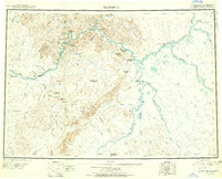 1950 Sleetmute1950 Print · USGSThe Kuskokwim River corridor in the 1950s was a hub of interior Alaskan trade, where commerce relied on seasonal waterways and winter trails. Researchers can trace historic river outposts like Mellicks Trading Post, the Iditarod Winter Trail, and the remnants of Kolmakof Fort (Ruins).2 unique versions available
 - 1954 Map of Sleetmute, 1967 Print
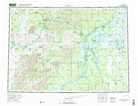 1954 Sleetmute1967 Print · USGSThe Kuskokwim River corridor in the mid-1950s reveals a network of trade sites and riverside villages between the Horn and Chuilnuk Mountains. Genealogists and researchers can locate remote outposts like Mellicks Trading Post, Red Devil, and the former Kolmakof village site.2 unique versions available
 - 1954 Map of Sleetmute A-5, 1968 Print
 1954 Sleetmute A-51968 Print · USGSThe mid-century Alaska wilderness comes into focus here, showing the remote Kuskokwim region as it was surveyed by air in the fifties. Researchers can trace the early riverside settlements of Nogamut and Nugamut or locate isolated cabins along the Holitna River.
 - 2019 Map of Sleetmute A-5 SE, 2019 Print
 2019 Sleetmute A-5 SE2019 Print · USGSThe interior Alaska wilderness near Bethel is defined by its winding waterways in the late twenty-tens. Researchers can trace the shifting course of the Holitna River and the drainage of Portage Creek across a landscape of high relief.
End of results
Showing maps 1-4 of 4
Frequently asked questions
- What are the different types of historical maps available for Nogamut?
- What is the oldest map of Nogamut?
- Where can I purchase historical maps of Nogamut for my home or office?
- Where can I download high-res historical maps of Nogamut?
- Are there historical topographic maps available for Nogamut?
- Is there historical aerial imagery available for Nogamut?
- Where are historical maps of Nogamut sourced from?