Old Maps of Nunapitchuk, Alaska for Metal Detecting
Plan your next treasure hunt with 5 historic maps of Nunapitchuk. Find old homesites, ghost towns, trails, and gathering spots that may be lost to time — perfect for identifying promising metal detecting locations.
- Locate forgotten sites: Uncover places like long-lost settlements, abandoned rail lines, or gathering spots.
- Plan better hunts: Use map overlays combined with LiDAR or satellite views to narrow in on historically rich areas.
- Made for detectorists: Thousands of hobbyists use these maps to discover relics, coins, and hidden history.
Use these historic maps to boost your research and find new opportunities beneath the surface of Nunapitchuk.
Nunapitchuk, AK maps
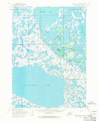
(5)- 1951 Map of Baird Inlet, 1953 Print
 1951 Baird Inlet1953 Print · USGSThe Yukon-Kuskokwim Delta's vast water-webbed landscape is shown here in the early fifties during a period of transition. Genealogists and researchers can trace the locations of traditional sites like Nunapitchuk alongside several sites marked as abandoned, such as Akulurak and Kinak.
 - 1954 Map of Baird Inlet, 1967 Print
 1954 Baird Inlet1967 Print · USGSThe Yukon-Kuskokwim Delta comes into focus in the mid-1950s, showing a vast network of tundra lakes and coastal estuaries. Researchers can locate active villages like Chefornak and Kasigluk or trace historical settlement sites such as Chakchak and Monrak.3 unique versions available
 - 1954 Map of Baird Inlet D-2, 1971 Print
 1954 Baird Inlet D-21971 Print · USGSThe Yukon-Kuskokwim Delta tundra is documented here in the mid-1950s, showing a transition between seasonal sites and established river settlements. Trace local history at Kasigluk, the Kvigatluk (Site), and the frozen routes of the Winter Trail.2 unique versions available
 - 2017 Map of Baird Inlet D-2 SE, 2017 Print
 2017 Baird Inlet D-2 SE2017 Print · USGSThe northern tundra near Bethel comes into focus during the late 2010s, showing a land defined by water and remote settlement. Researchers can trace the reach of the Johnson River and locate the community at Kasigluk alongside the vital Kasigluk Airport.
 - 2017 Map of Baird Inlet D-2 NE, 2017 Print
 2017 Baird Inlet D-2 NE2017 Print · USGSThe village of Nunapitchuk and its surrounding tundra waterways are documented in this 2017 study of the Yukon-Kuskokwim Delta. Researchers can trace the Old Kasigluk-Main Road and locate the Nunapitchuk Airport near the banks of the Johnson River.
End of results
Showing maps 1-5 of 5
Top cities near Nunapitchuk
Frequently asked questions
- What are the different types of historical maps available for Nunapitchuk?
- What is the oldest map of Nunapitchuk?
- Where can I purchase historical maps of Nunapitchuk for my home or office?
- Where can I download high-res historical maps of Nunapitchuk?
- Are there historical topographic maps available for Nunapitchuk?
- Is there historical aerial imagery available for Nunapitchuk?
- Where are historical maps of Nunapitchuk sourced from?