Old Maps of Nyac, Alaska for Academic Research
Study the evolution of Nyac with 5 high-resolution historic maps. Whether you're teaching, researching, or modeling changes in land use, these maps provide essential visual documentation of urban, environmental, and geographic change.
- Analyze long-term change: Track patterns in development, transportation, and natural features.
- Ideal for environmental or urban studies: Support academic projects with primary historical map data.
- Use in the classroom or lab: Educators and researchers rely on these maps to bring historical context to life.
These maps are a powerful tool for teaching, research, and visualizing how Nyac has changed over the decades.
Nyac, AK maps
(5)- 1947 Map of Russian Mission, 1957 Print
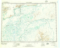 1947 Russian Mission1957 Print · USGSSouthwest Alaska in the late 1940s is mapped here as a vast network of river settlements and mountain outposts. Researchers can trace historic river life and early aviation at Russian Mission, Kako Air Field, and Crow Village.2 unique versions available
 - 1950 Map of Russian Mission
 1950 Russian Mission1950 Print · USGSThe Yukon-Kuskokwim Delta region comes alive in the early post-war era, showing the river-bound lifeways of the Alaskan interior. Local historians and genealogists can trace remote outposts like Russian Mission, Dogfish Village, and Nyac, or locate family sites like Phillips Broe.
 - 1954 Map of Russian Mission A-3, 1965 Print
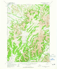 1954 Russian Mission A-31965 Print · USGSThe Alaskan interior near Bethel comes into focus during the mid-1950s, highlighting a landscape of mining-era landmarks and complex river systems. Trace the winding paths of the Tuluksak River and Bonanza Creek, or locate high points like Mount Hamilton.2 unique versions available
 - 1980 Map of Russian Mission
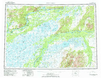 1980 Russian Mission1980 Print · USGSThe Yukon and Kuskokwim river basins are detailed here during the late twentieth century, showing a network of remote villages and seasonal camps. Researchers can trace traditional travel routes and settlements like Russian Mission, Chuathbaluk, and the historic Portage Trail.3 unique versions available
 - 2019 Map of Russian Mission A-3 SW, 2019 Print
 2019 Russian Mission A-3 SW2019 Print · USGSThe headwaters of the Tuluksak River are captured here in 2019, showing the mining-influenced terrain of the Bethel Census Area. Researchers can trace the drainages of Shovel Gulch and Mary Lou Gulch near the settlement at Nyac.
End of results
Showing maps 1-5 of 5
Frequently asked questions
- What are the different types of historical maps available for Nyac?
- What is the oldest map of Nyac?
- Where can I purchase historical maps of Nyac for my home or office?
- Where can I download high-res historical maps of Nyac?
- Are there historical topographic maps available for Nyac?
- Is there historical aerial imagery available for Nyac?
- Where are historical maps of Nyac sourced from?