Old Maps of Old Chevak, Alaska for Metal Detecting
Plan your next treasure hunt with 5 historic maps of Old Chevak. Find old homesites, ghost towns, trails, and gathering spots that may be lost to time — perfect for identifying promising metal detecting locations.
- Locate forgotten sites: Uncover places like long-lost settlements, abandoned rail lines, or gathering spots.
- Plan better hunts: Use map overlays combined with LiDAR or satellite views to narrow in on historically rich areas.
- Made for detectorists: Thousands of hobbyists use these maps to discover relics, coins, and hidden history.
Use these historic maps to boost your research and find new opportunities beneath the surface of Old Chevak.
Old Chevak, AK maps
(5)- 1951 Map of Hooper Bay
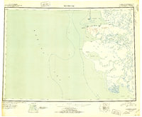 1951 Hooper Bay1951 Print · USGSThe Yukon-Kuskokwim Delta coast is captured here just after the war, showing the remote settlements and river systems of the Bering Sea. You can trace the Winter Trail between Scammon Bay and Kutmiut or locate the old landing at Hooper Bay.
 - 1953 Map of Hooper Bay, 1963 Print
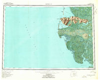 1953 Hooper Bay1963 Print · USGSThe Bering Sea coast near the Yukon-Kuskokwim Delta appears here in the early fifties, showing a land of tidal rivers and tundra. Trace the locations of Hooper Bay, Chevak, and Old Chevak alongside the prominent As Kinuk Mountains.5 unique versions available
 - 1953 Map of Hooper Bay B-2, 1965 Print
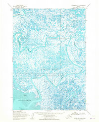 1953 Hooper Bay B-21965 Print · USGSThe coastal delta of western Alaska is captured here in the early 1950s, showing a labyrinth of tundra ponds and tidal rivers. Researchers can locate the settlement of Old Chevak and trace the winding courses of the Kashunuk River and Keoklevik River.2 unique versions available
 - 1964 Map of Hooper Bay
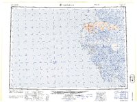 1964 Hooper Bay1964 Print · USGSCoastal Alaska's Yukon-Kuskokwim Delta is captured in the mid-sixties, a time when river travel and seasonal settlements defined the region. Genealogists and historians can trace the foundations of Hooper Bay and Chevak, or locate traditional sites like Paimiut and Old Chevak.
 - 2020 Map of Hooper Bay B-2 NE, 2020 Print
 2020 Hooper Bay B-2 NE2020 Print · USGSCoastal Alaska in the Yukon-Kuskokwim Delta is captured in this recent survey of the Kusilvak Census Area. Researchers can trace the winding paths of the Kashunuk River and the Keoklevik River as they meander through a dense network of subarctic wetlands and ponds.
End of results
Showing maps 1-5 of 5
Top cities near Old Chevak
Frequently asked questions
- What are the different types of historical maps available for Old Chevak?
- What is the oldest map of Old Chevak?
- Where can I purchase historical maps of Old Chevak for my home or office?
- Where can I download high-res historical maps of Old Chevak?
- Are there historical topographic maps available for Old Chevak?
- Is there historical aerial imagery available for Old Chevak?
- Where are historical maps of Old Chevak sourced from?