1900s (20th Century) Maps of Shishmaref, Alaska
Explore 4 historic maps of Shishmaref from the 1900s (20th Century). These maps offer a rare glimpse into what life looked like during the 1900s — showing old roads, neighborhoods, homes, and landmarks that have changed or disappeared over time.
Whether you're researching your family's past, planning a metal detecting trip, or studying how Shishmaref's landscape evolved across the 1900s, these high-resolution maps are a powerful tool for exploring the history of this region.
- Focus on a specific era: All maps on this page are from the 1900s, giving you a focused view of this time period.
- See what’s changed: Compare century-old streets, trails, and buildings to today's modern landscape using overlays and satellite layers.
- Research with precision: Use these maps for genealogy, historical research, land use analysis, or educational projects.
- View, download, or print: Maps are fully viewable online in high resolution, and can be downloaded or printed for your own records.
Start exploring Shishmaref's history through authentic maps from the 1900s. This is your window into the past.
Shishmaref, AK maps
(4)- 1950 Map of Shishmaref, 1956 Print
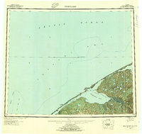 1950 Shishmaref1956 Print · USGSThe Seward Peninsula shoreline at the dawn of the fifties reveals a landscape of barrier islands and isolated tundra outposts. Researchers can trace seasonal routes like the Winter Trail and locate the historic Shishmaref village on Sarichef Island.5 unique versions available
 - 1950 Map of Shishmaref A-3, 1957 Print
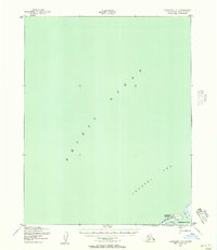
 1950 Shishmaref A-31957 Print · USGSThe Chukchi Sea coastline near the Shishmaref Inlet is captured here in the mid-twentieth century. Researchers can trace the seasonal Winter Trail and locate early aviation landmarks like the Landing Area on Sarichef Island.2 unique versions available
 - 1950 Map of Shishmaref B-3, 1957 Print
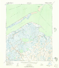
 1950 Shishmaref B-31957 Print · USGSSarichef Island and the village of Shishmaref sit along the Chukchi Sea in the 1950s. Trace the mid-century footprint of this Arctic outpost through its Landing Strip, Light, and the Winter Trail leading along Shishmaref Inlet.2 unique versions available
 - 1951 Map of Shishmaref
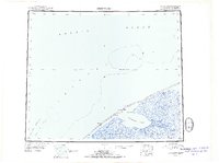 1951 Shishmaref1951 Print · USGSThe Seward Peninsula and Sarichef Island are captured here during the early fifties, showing the coastal subsistence landscape of the Alaskan Arctic. Researchers can locate remote outposts like Sinrazat and Kividlow, or trace the path of the Winter Trail as it skirts the Shishmaref Inlet.
End of results
Showing maps 1-4 of 4
Frequently asked questions
- What are the different types of historical maps available for Shishmaref?
- What is the oldest map of Shishmaref?
- Where can I purchase historical maps of Shishmaref for my home or office?
- Where can I download high-res historical maps of Shishmaref?
- Are there historical topographic maps available for Shishmaref?
- Is there historical aerial imagery available for Shishmaref?
- Where are historical maps of Shishmaref sourced from?