Old Maps of Shishmaref, Alaska for Genealogy
Trace your family roots with 6 historic maps of Shishmaref. These high-res maps reveal old neighborhoods, homesites, landmarks, and streets — helping you uncover where your ancestors lived and how the area evolved over time.
- Explore historic neighborhoods: Identify where your relatives may have lived in the 1800s or 1900s.
- Compare maps over time: Trace the changes in streets, buildings, and landmarks for multi-generational research.
- Perfect for genealogy & ancestry research: Used by family historians and researchers to map out lineage and migration.
These maps are an incredible resource for exploring your personal connection to Shishmaref's past.
Shishmaref, AK maps
(6)- 1950 Map of Shishmaref, 1956 Print
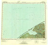 1950 Shishmaref1956 Print · USGSThe Seward Peninsula shoreline at the dawn of the fifties reveals a landscape of barrier islands and isolated tundra outposts. Researchers can trace seasonal routes like the Winter Trail and locate the historic Shishmaref village on Sarichef Island.5 unique versions available
 - 1950 Map of Shishmaref A-3, 1957 Print
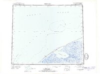
 1950 Shishmaref A-31957 Print · USGSThe Chukchi Sea coastline near the Shishmaref Inlet is captured here in the mid-twentieth century. Researchers can trace the seasonal Winter Trail and locate early aviation landmarks like the Landing Area on Sarichef Island.2 unique versions available
 - 1950 Map of Shishmaref B-3, 1957 Print
 1950 Shishmaref B-31957 Print · USGSSarichef Island and the village of Shishmaref sit along the Chukchi Sea in the 1950s. Trace the mid-century footprint of this Arctic outpost through its Landing Strip, Light, and the Winter Trail leading along Shishmaref Inlet.2 unique versions available
 - 1951 Map of Shishmaref
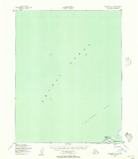
 1951 Shishmaref1951 Print · USGSThe Seward Peninsula and Sarichef Island are captured here during the early fifties, showing the coastal subsistence landscape of the Alaskan Arctic. Researchers can locate remote outposts like Sinrazat and Kividlow, or trace the path of the Winter Trail as it skirts the Shishmaref Inlet.
 - 2014 Map of Shishmaref B-3 SE, 2014 Print
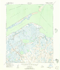
 2014 Shishmaref B-3 SE2014 Print · USGSShishmaref and Sarichef Island are captured in the early twenty-first century as they sit between the open sea and the inlet. Researchers can trace the layout of Shishmaref along Main Street and locate the critical Shishmaref Airport.
 - 2014 Map of Shishmaref A-3 NE, 2014 Print
 2014 Shishmaref A-3 NE2014 Print · USGSThe Seward Peninsula coastline appears as a delicate thread of barrier islands and inlets in this 2014 survey. Geographers and coastal researchers can trace the modern shoreline of Sarichef Island and the positioning of the Shishmaref Airport.
End of results
Showing maps 1-6 of 6
Frequently asked questions
- What are the different types of historical maps available for Shishmaref?
- What is the oldest map of Shishmaref?
- Where can I purchase historical maps of Shishmaref for my home or office?
- Where can I download high-res historical maps of Shishmaref?
- Are there historical topographic maps available for Shishmaref?
- Is there historical aerial imagery available for Shishmaref?
- Where are historical maps of Shishmaref sourced from?