Old Maps of Tatitlek, Alaska for Academic Research
Study the evolution of Tatitlek with 7 high-resolution historic maps. Whether you're teaching, researching, or modeling changes in land use, these maps provide essential visual documentation of urban, environmental, and geographic change.
- Analyze long-term change: Track patterns in development, transportation, and natural features.
- Ideal for environmental or urban studies: Support academic projects with primary historical map data.
- Use in the classroom or lab: Educators and researchers rely on these maps to bring historical context to life.
These maps are a powerful tool for teaching, research, and visualizing how Tatitlek has changed over the decades.
Tatitlek, AK maps
(7)- 1948 Map of Cordova, 1957 Print
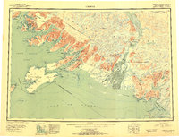
 1948 Cordova1957 Print · USGSCoastal Alaska in the late 1940s is defined by its deep-water inlets and the massive Copper River Delta. Genealogists and historians can trace old settlements like Katalla, Ellamar, and Nuchek alongside landmarks like the Cordova Airport.2 unique versions available
 - 1951 Map of Cordova
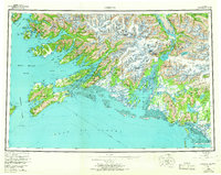
 1951 Cordova1951 Print · USGSThe Gulf of Alaska shoreline comes alive in the early fifties, detailing the intricate fjords and coastal settlements of Prince William Sound. Genealogists and historians can trace the Copper River and Northwestern RR and locate sites like Katalla, Ellamar, and Nuchek.3 unique versions available
 - 1951 Map of Cordova D-8, 1966 Print
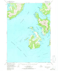 1951 Cordova D-81966 Print · USGSCoastal life in Prince William Sound comes into focus in the early fifties, showing a landscape shaped by mining and maritime travel. Researchers can trace the layout of Tatitlek and Ellamar, or locate the Wagoner Mine and the Seaplane Base.3 unique versions available
 - 1952 Map of Cordova D-8, 1954 Print
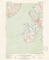 1952 Cordova D-81954 Print · USGSThe eastern reaches of Prince William Sound in the early fifties show a landscape of remote mining outposts and coastal villages. Researchers can trace historical sites like the Wagner Mine, the settlement of Ellamar, and the Cem near Tatitlek.2 unique versions available
 - 1959 Map of Cordova, 1966 Print
 1959 Cordova1966 Print · USGSCoastal life and the industrial legacy of the Copper River region are frozen in time on this mid-century survey of Prince William Sound. Genealogists and historians can trace the route of the Copper River and Northwestern RR or locate old settlements like Katalla, Ellamar, and Alaganik.6 unique versions available
 - 2018 Map of Cordova D-8 SE, 2018 Print
 2018 Cordova D-8 SE2018 Print · USGSCovers Tatitlek, including Unorganized Borough, United States, and other nearby areas
 - 2024 Map of Cordova D-8 SE, 2024 Print
 2024 Cordova D-8 SE2024 Print · USGSThe village of Tatitlek is shown at the edge of Prince William Sound in this recent survey. Researchers can trace the layout of this coastal community, including the Tatitlek Cem, Tatitlek Airpor, and the shores of Bligh Island.
End of results
Showing maps 1-7 of 7
Top cities near Tatitlek
Frequently asked questions
- What are the different types of historical maps available for Tatitlek?
- What is the oldest map of Tatitlek?
- Where can I purchase historical maps of Tatitlek for my home or office?
- Where can I download high-res historical maps of Tatitlek?
- Are there historical topographic maps available for Tatitlek?
- Is there historical aerial imagery available for Tatitlek?
- Where are historical maps of Tatitlek sourced from?