
1952 Map of Cordova D-8
USGS Topo · Published 1954About this map
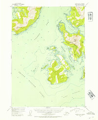
Ellamar and Tatitlek stand as the primary coastal settlements along the intricate shoreline of Prince William Sound in the early 1950s. This survey records the maritime and industrial footprint of the region, where the Chugach National Forest encompasses most of the land, save for these designated exclusion areas. Evidence of earlier 20th-century industry is visible through the Wagner Mine and Rus Mine, located east of Virgin Bay. The map provides detailed hydrography for Valdez Arm and Port Fidalgo, marking hazards like Reef Island and the complex channels of the Tatitlek Narrows. Local landmarks such as Ellamar Mountain and the heights of Bligh Island dominate the topography, while a Cem near Tatitlek offers a specific point of interest for genealogists tracing lineage in these Alaskan coastal communities.
Find a feature on this map
31 named features on this map. Tap any name to fly to it.
Don’t see what you’re looking for? This feature index may not catch every label — zoom into the map to look around manually.
Map Details
Editions of this 1952 Cordova D-8 Map
2 editions found
Other maps of this area

1948 · Cordova
USGS Topo · 1:250,000

1950 · Cordova C-7
USGS Topo · 1:63,360

1950 · Cordova D-7
USGS Topo · 1:63,360

1950 · Cordova C-8
USGS Topo · 1:63,360

1951 · Seward
USGS Topo · 1:250,000

1951 · Anchorage
USGS Topo · 1:250,000

1951 · Cordova
USGS Topo · 1:250,000

1951 · Seward D-1
USGS Topo · 1:63,360

1951 · Cordova D-8
USGS Topo · 1:63,360

1951 · Seward C-1
USGS Topo · 1:63,360