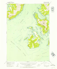
1952 Map of Cordova D-8
USGS Topo · Published 1954About this map
The coastal settlement of Tatitlek and the nearby site of Ellamar anchor this 1950s study of the eastern reaches of Prince William Sound. The map reveals a maritime landscape defined by deep-water passages and industrial extraction, most notably the Wagner Mine and Rua Mine situated on the slopes above Boulder Bay. These mines, along with a small cemetery near the shore, indicate the localized human footprint within the larger Chugach National Forest.
Find a feature on this map
33 named features on this map. Tap any name to fly to it.
Don’t see what you’re looking for? This feature index may not catch every label — zoom into the map to look around manually.
Map Details
Editions of this 1952 Cordova D-8 Map
2 editions found

Other maps of this area

1948 · Cordova
USGS Topo · 1:250,000

1950 · Cordova C-7
USGS Topo · 1:63,360

1950 · Cordova D-7
USGS Topo · 1:63,360

1950 · Cordova C-8
USGS Topo · 1:63,360

1951 · Seward
USGS Topo · 1:250,000

1951 · Anchorage
USGS Topo · 1:250,000

1951 · Cordova
USGS Topo · 1:250,000

1951 · Seward D-1
USGS Topo · 1:63,360

1951 · Cordova D-8
USGS Topo · 1:63,360

1951 · Seward C-1
USGS Topo · 1:63,360