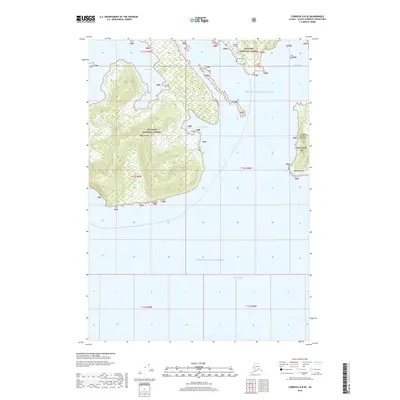
2018 Map of Cordova D-8 SE
USGS Topo · Published 2018About this map
Bligh Island dominates the western portion of this maritime survey, situated within the expansive waters of Prince William Sound. The island’s steep topography is captured with precise contouring, rising from the shoreline of West Bay and reaching across the southern reach of the sound toward Port Fidalgo. On the mainland to the northeast, the Chugach National Forest provides the setting for the local infrastructure near the settlement of Tatitlek. The coastal geography is highly articulated, featuring prominent landmarks such as Bidarka Point and the Copper Mountain Peninsula. Genealogists and local historians will find the Tatitlek Cem and Tatitlek Airport clearly marked, offering a look at the essential connection points and heritage sites for this coastal community during the early 21st century.
Find a feature on this map
19 named features on this map. Tap any name to fly to it.
Don’t see what you’re looking for? This feature index may not catch every label — zoom into the map to look around manually.
Map Details
Editions of this 2018 Cordova D-8 SE Map
This is the sole edition of this map. No revisions or reprints were ever made.
Other maps of this area

1948 · Cordova
USGS Topo · 1:250,000

1950 · Cordova C-7
USGS Topo · 1:63,360

1950 · Cordova D-7
USGS Topo · 1:63,360

1950 · Cordova C-8
USGS Topo · 1:63,360

1951 · Cordova
USGS Topo · 1:250,000

1951 · Cordova D-8
USGS Topo · 1:63,360

1952 · Cordova D-8
USGS Topo · 1:63,360

1952 · Cordova C-8
USGS Topo · 1:63,360

1952 · Cordova D-7
USGS Topo · 1:63,360
1953 · Cordova C-7
USGS Topo · 1:63,360