Old Maps of Tonsina, Alaska for Hiking & Exploration
Hike through history with 8 historic maps of Tonsina. Explore old trails, ghost towns, and forgotten backroads — perfect for outdoor adventurers and local explorers.
- Rediscover forgotten places: Map out old mining camps, roads, and footpaths that no longer exist on modern maps.
- Layer with modern tools: Combine with LiDAR or satellite views to plan hikes through historical terrain.
- Made for exploration: Popular among hikers, overlanders, and local history lovers.
Use these maps to find adventure and explore the hidden past of Tonsina.
Tonsina, AK maps
(8)- 1951 Map of Valdez C-4, 1964 Print
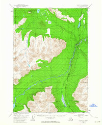 1951 Valdez C-41964 Print · USGSAlaska's interior river valleys are documented here in the early fifties as the region's highway and aviation networks were being established. Trace the early layout of Tonsina, locate the Gaglow Siding, and see the original path of the Richardson Highway near Pippin Lake.2 unique versions available
 - 1952 Map of Valdez
 1952 Valdez1952 Print · USGSCoastal Alaska met the interior via mountain passes and river valleys during the mid-century, before the 1964 earthquake altered the shoreline. Trace mining history at Midas Camp and Cliff Mine, or locate remote stations like Tiekel Cache and Copper Center.4 unique versions available
 - 1953 Map of Valdez C-4, 1955 Print
 1953 Valdez C-41955 Print · USGSThe Tonsina River valley was a critical transportation corridor in the early fifties as the Alaskan interior opened further to development. Genealogists and local historians can trace the early settlement of Tonsina, its Cem, and infrastructure like the Richardson Highway and various Gravel Pits.
 - 1960 Map of Valdez, 1967 Print
 1960 Valdez1967 Print · USGSCoastal and interior Alaska meet in this mid-century study of the Chugach Mountains and the copper-rich river valleys. Trace the legacy of early industry along the Copper River and Northwestern Railroad and locate settlements like Copper Center, Chitina, and Fort Liscum.6 unique versions available
 - 1996 Map of Valdez C-4, 2001 Print
 1996 Valdez C-42001 Print · USGSIn the mid-1990s, the Copper River basin was a vital energy corridor where the modern pipeline met historic highway routes. Researchers can trace the path of the Trans-Alaska Pipeline past Tonsina, locating local landmarks like the Cem and Pippin Lake.
 - 2016 Map of Valdez C-4 NE, 2016 Print
 2016 Valdez C-4 NE2016 Print · USGSCovers Tonsina, including Unorganized Borough, United States, and other nearby areas
 - 2019 Map of Valdez C-4 NE, 2019 Print
 2019 Valdez C-4 NE2019 Print · USGSCovers Tonsina, including Unorganized Borough, United States, and other nearby areas
 - 2023 Map of Valdez C-4 NE, 2023 Print
 2023 Valdez C-4 NE2023 Print · USGSThe Copper River Census Area is shown in the early twenty-first century as the trans-Alaska corridor traverses the interior. Trace the path of the Alaska Pipeline alongside the Richardson Highway past Tonsina and Pippin Lake.
End of results
Showing maps 1-8 of 8
Frequently asked questions
- What are the different types of historical maps available for Tonsina?
- What is the oldest map of Tonsina?
- Where can I purchase historical maps of Tonsina for my home or office?
- Where can I download high-res historical maps of Tonsina?
- Are there historical topographic maps available for Tonsina?
- Is there historical aerial imagery available for Tonsina?
- Where are historical maps of Tonsina sourced from?