
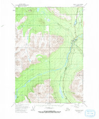
1951 Map of Valdez C-4
USGS Topo · Published 1964About this map
Tonsina River and the Copper River dominate this interior Alaskan landscape, where the primary transport corridor follows the Richardson Highway. This mid-century survey captures the settlement at Tonsina and the nearby Gaglow Siding during a period when remote transportation infrastructure was critical to the region's connectivity. The map identifies key aviation and transit points like a Landing Strip and various benchmark stations used for high-altitude navigation.
Find a feature on this map
25 named features on this map. Tap any name to fly to it.
Don’t see what you’re looking for? This feature index may not catch every label — zoom into the map to look around manually.
Map Details
Editions of this 1951 Valdez C-4 Map
2 editions found
Other maps of this area

1948 · Valdez D-5
USGS Topo · 1:63,360

1949 · Valdez D-4
USGS Topo · 1:63,360

1951 · Valdez D-5
USGS Topo · 1:63,360

1951 · Valdez B-3
USGS Topo · 1:63,360

1951 · Valdez B-5
USGS Topo · 1:63,360

1951 · Valdez C-3
USGS Topo · 1:63,360

1951 · Valdez B-4
USGS Topo · 1:63,360

1951 · Valdez C-5
USGS Topo · 1:63,360

1952 · Valdez
USGS Topo · 1:250,000

1952 · Valdez D-4
USGS Topo · 1:63,360