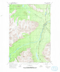
1951 Map of Valdez C-4
USGS Topo · Published 1971About this map
Tonsina serves as a central point of settlement in this interior Alaskan landscape, situated where the Richardson Highway crosses the Tonsina River. The surrounding terrain is defined by the convergence of several major waterways, including Squirrel Creek, Bernard Creek, and the Little Tonsina River. In the early 1950s, this area supported essential transportation and communication infrastructure, evidenced by the presence of a Landing Strip, a Gaging Sta, and the Squirrel Creek Campground.
Find a feature on this map
22 named features on this map. Tap any name to fly to it.
Don’t see what you’re looking for? This feature index may not catch every label — zoom into the map to look around manually.
Map Details
Editions of this 1951 Valdez C-4 Map
2 editions found
Other maps of this area

1948 · Valdez D-5
USGS Topo · 1:63,360

1949 · Valdez D-4
USGS Topo · 1:63,360

1951 · Valdez D-5
USGS Topo · 1:63,360

1951 · Valdez B-3
USGS Topo · 1:63,360

1951 · Valdez B-5
USGS Topo · 1:63,360

1951 · Valdez C-3
USGS Topo · 1:63,360

1951 · Valdez C-4
USGS Topo · 1:63,360

1951 · Valdez B-4
USGS Topo · 1:63,360

1951 · Valdez C-5
USGS Topo · 1:63,360

1952 · Valdez
USGS Topo · 1:250,000