1900s (20th Century) Maps of Tuluksak, Alaska
Explore 4 historic maps of Tuluksak from the 1900s (20th Century). These maps offer a rare glimpse into what life looked like during the 1900s — showing old roads, neighborhoods, homes, and landmarks that have changed or disappeared over time.
Whether you're researching your family's past, planning a metal detecting trip, or studying how Tuluksak's landscape evolved across the 1900s, these high-resolution maps are a powerful tool for exploring the history of this region.
- Focus on a specific era: All maps on this page are from the 1900s, giving you a focused view of this time period.
- See what’s changed: Compare century-old streets, trails, and buildings to today's modern landscape using overlays and satellite layers.
- Research with precision: Use these maps for genealogy, historical research, land use analysis, or educational projects.
- View, download, or print: Maps are fully viewable online in high resolution, and can be downloaded or printed for your own records.
Start exploring Tuluksak's history through authentic maps from the 1900s. This is your window into the past.
Tuluksak, AK maps
(4)- 1947 Map of Russian Mission, 1957 Print
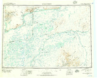 1947 Russian Mission1957 Print · USGSSouthwest Alaska in the late 1940s is mapped here as a vast network of river settlements and mountain outposts. Researchers can trace historic river life and early aviation at Russian Mission, Kako Air Field, and Crow Village.2 unique versions available
 - 1950 Map of Russian Mission
 1950 Russian Mission1950 Print · USGSThe Yukon-Kuskokwim Delta region comes alive in the early post-war era, showing the river-bound lifeways of the Alaskan interior. Local historians and genealogists can trace remote outposts like Russian Mission, Dogfish Village, and Nyac, or locate family sites like Phillips Broe.
 - 1954 Map of Russian Mission A-6, 1962 Print
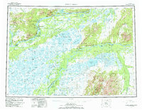
 1954 Russian Mission A-61962 Print · USGSThe Kuskokwim Delta in the mid-fifties is captured here during a period of vital river-based transport and seasonal movement. Researchers can trace the layout of Tuluksak and locate isolated Cabins along the banks of the Tuluksak River and Mishevik Slough.
 - 1980 Map of Russian Mission
 1980 Russian Mission1980 Print · USGSThe Yukon and Kuskokwim river basins are detailed here during the late twentieth century, showing a network of remote villages and seasonal camps. Researchers can trace traditional travel routes and settlements like Russian Mission, Chuathbaluk, and the historic Portage Trail.3 unique versions available
End of results
Showing maps 1-4 of 4
Frequently asked questions
- What are the different types of historical maps available for Tuluksak?
- What is the oldest map of Tuluksak?
- Where can I purchase historical maps of Tuluksak for my home or office?
- Where can I download high-res historical maps of Tuluksak?
- Are there historical topographic maps available for Tuluksak?
- Is there historical aerial imagery available for Tuluksak?
- Where are historical maps of Tuluksak sourced from?